Geolocate

Oakland topographic map

Click on the map to display elevation.

About this map

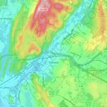
Name: Oakland topographic map, elevation, terrain.

Location: Oakland, Bergen County, New Jersey, 07436, United States (40.99209 -74.27248 41.06382 -74.20177)

Average elevation: 133 m

Minimum elevation: 57 m

Maximum elevation: 297 m

Other topographic maps

Click on a map to view its topography, its elevation and its terrain.

Ridgewood

United States > New Jersey > Bergen County

Average elevation: 56 m

Stag Hill

United States > New Jersey > Bergen County > Mahwah

Average elevation: 204 m

Drag Hill

United States > New Jersey > Bergen County > Mahwah

Average elevation: 252 m

Darlington

United States > New Jersey > Bergen County > Mahwah

Average elevation: 129 m

Green Hill

United States > New Jersey > Bergen County > Mahwah

Average elevation: 175 m

Fardale

United States > New Jersey > Bergen County > Mahwah

Average elevation: 124 m

Cragmere

United States > New Jersey > Bergen County > Mahwah

Average elevation: 136 m

Teterboro

United States > New Jersey > Bergen County > Teterboro

Average elevation: 12 m

Westwood

United States > New Jersey > Bergen County > Westwood > Westwood

Average elevation: 31 m

Gear up for your next adventure:

🥾Trail Hiking Boots - Supportive boots for rough trails
🥾All-Terrain Hiking Boots - Versatile boots for varied hiking conditions
🚲MTB Frame Bag - Carry tools and maps directly on your bicycle frame
🧼Biodegradable Camp Soap - Environmentally friendly cleaning for gear and body
🥾Waterproof Hiking Shoes - Durable shoes for wet and rugged trails

As an Amazon Associate, this site earns from qualifying purchases at no extra cost to you.