
Bradenton topographic map
Click on the map to display elevation.
Bradenton
Bradenton was affected by World War II like many other cities in Florida and the United States. During the war, Manatee County had its own Civil Defense battalion in it with two subunits existing in Bradenton and another for nearby Manatee. A recreational center was opened in March 1942 at a building on the intersection of 6th Avenue and 12th Street West in the downtown area to be used by soldiers. The recreation center closed in November 1945 and was popular with local soldiers and visited even by those who were stationed outside of Bradenton. Police Chief Clyde Benton expanded the police force by naming 45 officers to serve without pay during the war. Camp Weatherford located at LECOM Field existed for eight months at some point during the war as a training center for the US Army Signal Corps. About 350 soldiers were trained there during its existence. The camp itself often had an issue with being flooded because of the rainy climate, showers at the camp occurring often, clothes being washed, its low elevation and is located nearby to Wares Creek. A soldier named Joe Grossman at the camp ran a radio show broadcasting on WSPB called Weatherford Shinings. Local residents accommodated the troops stationed at the base in a variety of ways. Bradenton merged with nearby Manatee (incorporated in 1888) in 1943. Manatee faced similar financial problems as Bradenton did in regards to their bonds and faced high debt levels as a result but Manatee could not pay off the bonds.
About this map
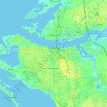
Name: Bradenton topographic map, elevation, terrain.
Location: Bradenton, Manatee County, Florida, United States (27.45516 -82.69069 27.52296 -82.47943)
Average elevation: 5 m
Minimum elevation: -5 m
Maximum elevation: 17 m
Other topographic maps
Click on a map to view its topography, its elevation and its terrain.
Parrish
United States > Florida > Manatee County
Parrish features a predominantly flat terrain with an average elevation of approximately 36 feet above sea level. The area's landscape is characterized by gently rolling hills and low-lying regions, making it typical of the Central Florida topography. Surrounding Parrish are numerous wetlands and drainage…
Average elevation: 12 m
Anna Maria island
United States > Florida > Manatee County
Anna Maria Island features a flat, sandy topography typical of a barrier island on the Gulf Coast. With an average elevation of around 15 feet above sea level, the terrain includes broad beaches, low dunes, and narrow stretches of sandy soil, making it highly vulnerable to storm surges and tidal flooding. The…
Average elevation: 2 m
Myakka City
United States > Florida > Manatee County
Myakka City (also Myakka) is an unincorporated community in southeastern Manatee County, Florida, United States. It lies along State Road 70 near the city of Bradenton, the county seat of Manatee County. Its elevation is 43 feet (13 m), and it is located at 27°20′59″N 82°9′41″W / 27.34972°N…
Average elevation: 14 m
West Samoset
United States > Florida > Manatee County > South Bradenton > West Samoset
Average elevation: 11 m
Myakka City
United States > Florida > Manatee County
Myakka City (also Myakka) is an unincorporated community in southeastern Manatee County, Florida, United States. It lies along State Road 70 near the city of Bradenton, the county seat of Manatee County. Its elevation is 43 feet (13 m), and it is located at 27°20′59″N 82°9′41″W / 27.34972°N…
Average elevation: 14 m