Geolocate

War topographic map

Click on the map to display elevation.

About this map

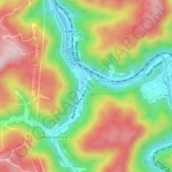
Name: War topographic map, elevation, terrain.

Location: War, McDowell County, West Virginia, 24892, United States (37.28803 -81.69734 37.31386 -81.66534)

Average elevation: 555 m

Minimum elevation: 400 m

Maximum elevation: 725 m

Other topographic maps

Click on a map to view its topography, its elevation and its terrain.

English

United States > West Virginia > McDowell County

Average elevation: 558 m

Ennis

United States > West Virginia > McDowell County

Average elevation: 730 m

Carswell

United States > West Virginia > McDowell County

Average elevation: 606 m

Faraday

United States > West Virginia > McDowell County

Average elevation: 639 m

Atwell

United States > West Virginia > McDowell County

Average elevation: 559 m

Rift

United States > West Virginia > McDowell County

Average elevation: 553 m

Vivian

United States > West Virginia > McDowell County

Average elevation: 619 m

Squire

United States > West Virginia > McDowell County

Average elevation: 635 m

Worth

United States > West Virginia > McDowell County

Average elevation: 731 m

Yerba

United States > West Virginia > McDowell County

Average elevation: 563 m

Faraday

United States > West Virginia > McDowell County > Faraday

Average elevation: 639 m

Gear up for your next adventure:

🔦LED Headlamp - Hands-free lighting for early morning starts or late finishes
🧦Thermal Socks - Warm socks for winter hiking or camping
🥾Trail Hiking Socks - Comfortable socks to prevent blisters and fatigue
🥾Approach Boots - Comfortable boots for hiking and climbing approaches
💡LED Headlamp - Hands-free illumination for night hiking and camping

As an Amazon Associate, this site earns from qualifying purchases at no extra cost to you.