Geolocate

Squire topographic map

Click on the map to display elevation.

About this map

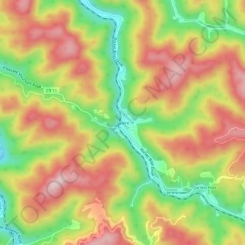
Name: Squire topographic map, elevation, terrain.

Location: Squire, McDowell County, West Virginia, 24884, United States (37.21845 -81.62983 37.25845 -81.58983)

Average elevation: 635 m

Minimum elevation: 477 m

Maximum elevation: 774 m

Other topographic maps

Click on a map to view its topography, its elevation and its terrain.

War

United States > West Virginia > McDowell County

Average elevation: 555 m

Bradshaw

United States > West Virginia > McDowell County

Average elevation: 516 m

Welch

United States > West Virginia > McDowell County

Average elevation: 559 m

Anawalt

United States > West Virginia > McDowell County

Average elevation: 643 m

Bradshaw

United States > West Virginia > McDowell County

Average elevation: 516 m

Gear up for your next adventure:

🥾Trail Hiking Socks - Comfortable socks to prevent blisters and fatigue
🛶Waterproof Dry Bags - Keep electronics and clothes dry during river crossings
🥾Trail Hiking Shoes - Durable shoes designed for rugged trails
👖Convertible Hiking Pants - Zip-off legs to adapt to changing weather conditions
🧦Hiking Socks - Moisture-wicking and comfortable socks for long hikes

As an Amazon Associate, this site earns from qualifying purchases at no extra cost to you.