Geolocate

Yerba topographic map

Click on the map to display elevation.

About this map

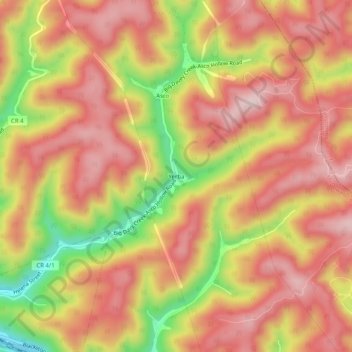
Name: Yerba topographic map, elevation, terrain.

Location: Yerba, McDowell County, West Virginia, 24828, United States (37.47289 -81.64400 37.51289 -81.60400)

Average elevation: 563 m

Minimum elevation: 359 m

Maximum elevation: 682 m

Other topographic maps

Click on a map to view its topography, its elevation and its terrain.

War

United States > West Virginia > McDowell County

Average elevation: 555 m

Bradshaw

United States > West Virginia > McDowell County

Average elevation: 516 m

Welch

United States > West Virginia > McDowell County

Average elevation: 559 m

Anawalt

United States > West Virginia > McDowell County

Average elevation: 643 m

Bradshaw

United States > West Virginia > McDowell County

Average elevation: 516 m

Gear up for your next adventure:

🧦Thermal Socks - Warm socks for winter hiking or camping
🧰Emergency Multi-Tool - Compact multi-tool for outdoor survival
🔋Solar Power Bank - Keep your GPS and devices charged during long outdoor trips
🧥Waterproof Hiking Jacket - Protect yourself from rain and wind while hiking
🗺️Topographic Maps - Detailed maps to explore trails, mountains, and wilderness areas

As an Amazon Associate, this site earns from qualifying purchases at no extra cost to you.