
Make a donation
Gear up for your next adventure:
As an Amazon Associate, this site earns from qualifying purchases at no extra cost to you.
Gooseberry Mesa topographic map
Click on the map to display elevation.
Make a donation
Gear up for your next adventure:
As an Amazon Associate, this site earns from qualifying purchases at no extra cost to you.
About this map
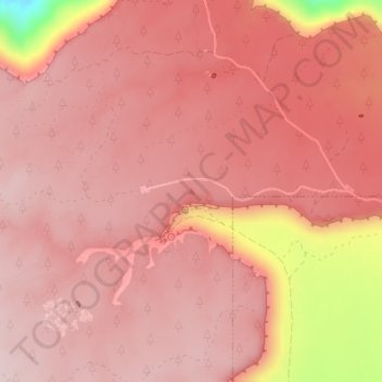
Name: Gooseberry Mesa topographic map, elevation, terrain.
Location: Gooseberry Mesa, Washington County, Utah, United States (37.14160 -113.16750 37.14170 -113.16740)
Average elevation: 1,541 m
Minimum elevation: 1,288 m
Maximum elevation: 1,602 m
Make a donation
Gear up for your next adventure:
As an Amazon Associate, this site earns from qualifying purchases at no extra cost to you.
Other topographic maps
Click on a map to view its topography, its elevation and its terrain.
Zion National Park
United States > Utah > Washington County
The 8,726-foot (2,660 m) summit of Horse Ranch Mountain is the highest point in the park; the lowest point is the 3,666-foot (1,117 m) elevation of Coal Pits Wash, creating a relief of about 5,100 feet (1,600 m).
Average elevation: 1,877 m
St. George
United States > Utah > Washington County
The St. George valley occasionally receives wet or slushy snowfall in the winter, but what accumulates usually melts off by the mid-to-late morning; the normal seasonal snowfall is 1.4 inches (3.6 cm). The earliest snowfall was measured on October 29, 1971, and the latest on April 11, 1927. The record…
Average elevation: 933 m
Make a donation
Gear up for your next adventure:
As an Amazon Associate, this site earns from qualifying purchases at no extra cost to you.
St. George
United States > Utah > Washington County
The St. George valley occasionally receives wet or slushy snowfall in the winter, but what accumulates usually melts off by the mid-to-late morning; the normal seasonal snowfall is 1.4 inches (3.6 cm). The earliest snowfall was measured on October 29, 1971, and the latest on April 11, 1927. The record…
Average elevation: 933 m
Zion National Park
United States > Utah > Washington County
The 8,726-foot (2,660 m) summit of Horse Ranch Mountain is the highest point in the park; the lowest point is the 3,666-foot (1,117 m) elevation of Coal Pits Wash, creating a relief of about 5,100 feet (1,600 m).
Average elevation: 1,877 m
Make a donation
Gear up for your next adventure:
As an Amazon Associate, this site earns from qualifying purchases at no extra cost to you.
Virgin
United States > Utah > Washington County
Virgin is a town in Washington County, Utah, United States. The population was 670 at the 2020 census. The first settlement at Virgin was made in 1858. It is located along the Virgin River (for which it is named), and not far from Zion National Park. The elevation is 3,606 feet (1,099 m). It lies on State…
Average elevation: 1,251 m
Veyo
United States > Utah > Washington County > Veyo
The elevation of Veyo is 4,485 feet (1,367 m).
Average elevation: 1,379 m
Make a donation
Gear up for your next adventure:
As an Amazon Associate, this site earns from qualifying purchases at no extra cost to you.
Zion National Park
United States > Utah > Washington County
The 8,726-foot (2,660 m) summit of Horse Ranch Mountain is the highest point in the park; the lowest point is the 3,666-foot (1,117 m) elevation of Coal Pits Wash, creating a relief of about 5,100 feet (1,600 m).
Average elevation: 1,877 m
Make a donation
Gear up for your next adventure:
As an Amazon Associate, this site earns from qualifying purchases at no extra cost to you.
St. George
United States > Utah > Washington County
According to the United States Census Bureau, the city has a total area of 77.151 square miles (199.82 km2), of which 0.003 square miles (0.0078 km2) (0.72%) is covered by water. St. George lies in a desert valley, with most of the city lying below 3,000 feet (900 m) in elevation. It is situated near a…
Average elevation: 933 m
Pine Valley Mountain Wilderness
United States > Utah > Washington County
Pine Valley Mountain Wilderness is a 50,232-acre (203.28 km2) wilderness area located in the Dixie National Forest in the U.S. state of Utah. It is the fourth-largest wilderness area located entirely within the state (following the High Uintas Wilderness, Zion Wilderness, and Cedar Mountain Wilderness). The…
Average elevation: 2,125 m
St. George
United States > Utah > Washington County
The St. George valley occasionally receives wet or slushy snowfall in the winter, but what accumulates usually melts off by the mid-to-late morning; the normal seasonal snowfall is 1.4 inches (3.6 cm). The earliest snowfall was measured on October 29, 1971, and the latest on April 11, 1927. The record…
Average elevation: 933 m
Make a donation
Gear up for your next adventure:
As an Amazon Associate, this site earns from qualifying purchases at no extra cost to you.
Zion Canyon
United States > Utah > Washington County
Geologically Zion Canyon is part of the Navajo sandstone Colorado Plateau, which contained many joints and cracks when first uplifted, one of which was cut by the North Fork of the Virgin River to become Zion Canyon. The river was the largest force in cutting the canyon, mostly by flash floods, as the average…
Average elevation: 1,821 m
Virgin
United States > Utah > Washington County
Virgin is a town in Washington County, Utah, United States. The population was 596 at the 2010 census. The first settlement at Virgin was made in 1858. It is located along the Virgin River (for which it is named), and not far from Zion National Park. The elevation is 3,606 feet (1,099 m). It lies on State…
Average elevation: 1,251 m
Zion National Park
United States > Utah > Washington County
The 8,726-foot (2,660 m) summit of Horse Ranch Mountain is the highest point in the park; the lowest point is the 3,666-foot (1,117 m) elevation of Coal Pits Wash, creating a relief of about 5,100 feet (1,600 m).
Average elevation: 1,877 m
Virgin
United States > Utah > Washington County
Virgin is a town in Washington County, Utah, United States. The population was 596 at the 2010 census. The first settlement at Virgin was made in 1858. It is located along the Virgin River (for which it is named), and not far from Zion National Park. The elevation is 3,606 feet (1,099 m). It lies on State…
Average elevation: 1,251 m
Make a donation
Gear up for your next adventure:
As an Amazon Associate, this site earns from qualifying purchases at no extra cost to you.
St. George
United States > Utah > Washington County
The St. George valley occasionally receives wet or slushy snowfall in the winter, but what accumulates usually melts off by the mid-to-late morning; the normal seasonal snowfall is 1.4 inches (3.6 cm). The earliest snowfall was measured on October 29, 1971, and the latest on April 11, 1927. The record…
Average elevation: 933 m
St. George
United States > Utah > Washington County
According to the United States Census Bureau, the city has an area of 77.151 square miles (199.82 km2), of which 0.003 square miles (0.0078 km2) (0.72% or about 2 ac) is covered by water. St. George is in a desert valley, with most of the city lying below 3,000 feet (900 m) in elevation. It is near a…
Average elevation: 933 m
Zion National Park
United States > Utah > Washington County
The 8,726-foot (2,660 m) summit of Horse Ranch Mountain is the highest point in the park; the lowest point is the 3,666-foot (1,117 m) elevation of Coal Pits Wash, creating a relief of about 5,100 feet (1,600 m).
Average elevation: 1,877 m
Make a donation
Gear up for your next adventure:
As an Amazon Associate, this site earns from qualifying purchases at no extra cost to you.
Cottonwood Canyon Wilderness
United States > Utah > Washington County > Washington
Average elevation: 1,213 m
St. George
United States > Utah > Washington County
According to the United States Census Bureau, the city has an area of 77.151 square miles (199.82 km2), of which 0.003 square miles (0.0078 km2) (0.72% or about 2 ac) is covered by water. St. George is in a desert valley, with most of the city lying below 3,000 feet (900 m) in elevation. It is near a…
Average elevation: 933 m
Make a donation
Gear up for your next adventure:
As an Amazon Associate, this site earns from qualifying purchases at no extra cost to you.
Make a donation
Gear up for your next adventure:
As an Amazon Associate, this site earns from qualifying purchases at no extra cost to you.