Geolocate

Haworth topographic map

Click on the map to display elevation.

About this map

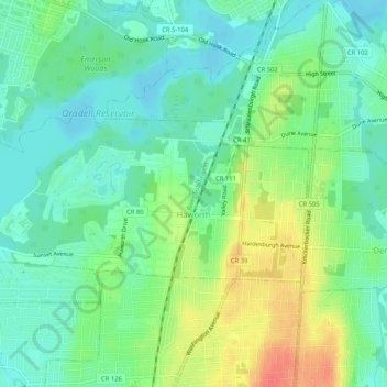
Name: Haworth topographic map, elevation, terrain.

Location: Haworth, Bergen County, New Jersey, 07641, United States (40.95412 -74.02658 40.97199 -73.97468)

Average elevation: 20 m

Minimum elevation: 2 m

Maximum elevation: 53 m

Other topographic maps

Click on a map to view its topography, its elevation and its terrain.

Ridgewood

United States > New Jersey > Bergen County

Average elevation: 56 m

Darlington

United States > New Jersey > Bergen County > Mahwah

Average elevation: 129 m

Drag Hill

United States > New Jersey > Bergen County > Mahwah

Average elevation: 252 m

Stag Hill

United States > New Jersey > Bergen County > Mahwah

Average elevation: 204 m

Green Hill

United States > New Jersey > Bergen County > Mahwah

Average elevation: 175 m

Fardale

United States > New Jersey > Bergen County > Mahwah

Average elevation: 124 m

Cragmere

United States > New Jersey > Bergen County > Mahwah

Average elevation: 136 m

Teterboro

United States > New Jersey > Bergen County > Teterboro

Average elevation: 12 m

Westwood

United States > New Jersey > Bergen County > Westwood > Westwood

Average elevation: 31 m

Gear up for your next adventure:

🧥Packable Rain Jacket - Breathable waterproof layer for unpredictable weather
🥾Trail Hiking Shoes - Durable shoes designed for rugged trails
🦌Outdoor Trail Camera - Monitor wildlife activity near your favorite spots
🛌Insulated Sleeping Pad - Critical thermal barrier between you and the cold ground
🥾Waterproof Hiking Shoes - Durable shoes for wet and rugged trails

As an Amazon Associate, this site earns from qualifying purchases at no extra cost to you.