
Utah Lake topographic map
Interactive map
Click on the map to display elevation.
About this map
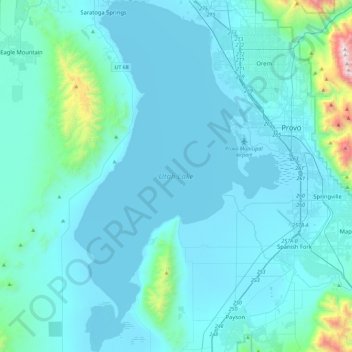
Name: Utah Lake topographic map, elevation, terrain.
Location: Utah Lake, Utah County, Utah, United States (40.00922 -111.94295 40.36121 -111.67254)
Average elevation: 1,512 m
Minimum elevation: 1,364 m
Maximum elevation: 3,293 m
Utah Lake is a shallow freshwater lake in the center of Utah County, Utah, United States. It lies in Utah Valley, surrounded by the Provo-Orem metropolitan area. The lake's only river outlet, the Jordan River, is a tributary of the Great Salt Lake. Evaporation accounts for 42% of the lake's outflow, which leaves the lake slightly saline. The elevation of the lake is at 4,489 feet (1,368 m) above sea level. If the lake's water level rises above that, the pumps and gates on the Jordan River are left open. Recently the lake has been at a lower level because of a drought.
Other topographic maps
Click on a map to view its topography, its elevation and its terrain.
Goshen
United States > Utah > Utah County
Goshen, Utah County, Utah, 84633, United States
Average elevation: 1,393 m
Orem
United States > Utah > Utah County
Orem, Utah County, Utah, United States
Average elevation: 1,458 m
Provo
United States > Utah > Utah County
Provo, Utah County, Utah, United States
Average elevation: 1,728 m
Eagle Mountain
United States > Utah > Utah County
Eagle Mountain, Utah County, Utah, 84005, United States
Average elevation: 1,589 m
Lehi
United States > Utah > Utah County
Lehi, Utah County, Utah, 84043, United States
Average elevation: 1,465 m
Lindon
United States > Utah > Utah County
Lindon, Utah County, Utah, 84042, United States
Average elevation: 1,537 m
West Mountain
United States > Utah > Utah County > West Mountain
West Mountain, Utah County, Utah, United States
Average elevation: 1,490 m
Benjamin
United States > Utah > Utah County
Benjamin, Utah County, Utah, United States
Average elevation: 1,380 m
Salem
United States > Utah > Utah County
Salem, Utah County, Utah, 84653, United States
Average elevation: 1,473 m
Santaquin
United States > Utah > Utah County
Santaquin, Utah County, Utah, 84655, United States
Average elevation: 1,644 m
Bicentennial Park
United States > Utah > Utah County > Provo
Bicentennial Park, Provost South, Provo, Utah County, Utah, United States
Average elevation: 1,466 m
Townsend
United States > Utah > Utah County > Genola
Townsend, Genola, Utah County, Utah, 84655, United States
Average elevation: 1,438 m
Pleasant Grove
United States > Utah > Utah County
Pleasant Grove, Utah County, Utah, 84062, United States
Average elevation: 1,609 m
Fairfield
United States > Utah > Utah County
Fairfield, Utah County, Utah, United States
Average elevation: 1,528 m
Saratoga Springs
United States > Utah > Utah County
Saratoga Springs, Utah County, Utah, 84045, United States
Average elevation: 1,495 m
Olmsted
United States > Utah > Utah County > Orem
Olmsted, Orem, Utah County, Utah, 84604, United States
Average elevation: 1,594 m
Springville
United States > Utah > Utah County
Springville, Utah County, Utah, 84663, United States
Average elevation: 1,566 m
Elk Ridge
United States > Utah > Utah County
Elk Ridge, Utah County, Utah, United States
Average elevation: 1,698 m
Alpine
United States > Utah > Utah County
Alpine, Utah County, Utah, 84004, United States
Average elevation: 1,664 m
Mapleton
United States > Utah > Utah County
Mapleton, Utah County, Utah, 84664, United States
Average elevation: 1,682 m
Vineyard
United States > Utah > Utah County
Vineyard, Utah County, Utah, 84059, United States
Average elevation: 1,382 m
Edgemont
United States > Utah > Utah County > Provo
Edgemont, Provo, Utah County, Utah, 84604, United States
Average elevation: 1,538 m
Aspen Grove
United States > Utah > Utah County
Aspen Grove, Utah County, Utah, United States
Average elevation: 2,358 m
Deer Creek
United States > Utah > Utah County
Deer Creek, Utah County, Utah, United States
Average elevation: 2,131 m
Saratoga Springs Park
United States > Utah > Utah County > Saratoga Springs > Saratoga Resort
Saratoga Springs Park, Saratoga Resort, Saratoga Springs, Utah County, Utah, United States
Average elevation: 1,375 m
Spanish Fork
United States > Utah > Utah County
Spanish Fork, Utah County, Utah, 84660, United States
Average elevation: 1,407 m
Payson
United States > Utah > Utah County
Payson, Utah County, Utah, 84651, United States
Average elevation: 1,473 m
Lone Peak Wilderness
United States > Utah > Utah County > Alpine
Lone Peak Wilderness, Alpine, Utah County, Utah, United States
Average elevation: 2,367 m
Lehi
United States > Utah > Utah County > Lehi
Lehi, Utah County, Utah, United States
Average elevation: 1,682 m
Geneva
United States > Utah > Utah County > Orem > Geneva
Geneva, Orem, Utah County, Utah, 84058, United States
Average elevation: 1,391 m
Cedar Hills
United States > Utah > Utah County
Cedar Hills, Utah County, Utah, United States
Average elevation: 1,562 m
American Fork
United States > Utah > Utah County
American Fork, Utah County, Utah, 84003, United States
Average elevation: 1,405 m
Highland
United States > Utah > Utah County
Highland, Utah County, Utah, United States
Average elevation: 1,514 m
Birdseye
United States > Utah > Utah County
Birdseye, Utah County, Utah, United States
Average elevation: 1,780 m