Geolocate

Lehi topographic map

Click on the map to display elevation.

About this map

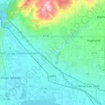
Name: Lehi topographic map, elevation, terrain.

Location: Lehi, Utah County, Utah, 84043, United States (40.35595 -111.94494 40.47172 -111.81529)

Average elevation: 1,465 m

Minimum elevation: 1,358 m

Maximum elevation: 2,029 m

Other topographic maps

Click on a map to view its topography, its elevation and its terrain.

Spanish Fork Peak

United States > Utah > Utah County

Average elevation: 2,720 m

Mount Timpanogos

United States > Utah > Utah County

Average elevation: 3,139 m

Bald Mountain Overlook

United States > Utah > Utah County

Average elevation: 2,552 m

Nutty Putty Cave

United States > Utah > Utah County

Average elevation: 1,547 m

Birdseye

United States > Utah > Utah County

Average elevation: 1,780 m

Lone Peak

United States > Utah > Utah County

Average elevation: 3,013 m

Curtis

United States > Utah > Utah County > Orem

Average elevation: 1,433 m

Caryhurst

United States > Utah > Utah County > Provo

Average elevation: 1,563 m

Mount Timpanogos

United States > Utah > Utah County

Average elevation: 3,139 m

Pleasant View

United States > Utah > Utah County > Provo

Average elevation: 1,446 m

Townsend

United States > Utah > Utah County > Genola

Average elevation: 1,438 m

Lone Peak

United States > Utah > Utah County

Average elevation: 3,013 m

Gear up for your next adventure:

🧶550 Survival Paracord - Versatile utility cord for emergency repairs and rigging
🥾Hiking Shoes - Durable and comfortable shoes for trail hiking
🚲Heavy Duty Bike Lock - Secure your bike at the trailhead or during stops
Camping Essentials - All-in-one gear for a comfortable camping trip
🧴Sunscreen SPF - Broad-spectrum sunscreen for outdoor activities

As an Amazon Associate, this site earns from qualifying purchases at no extra cost to you.