Geolocate

Alpine topographic map

Click on the map to display elevation.

About this map

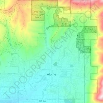
Name: Alpine topographic map, elevation, terrain.

Location: Alpine, Utah County, Utah, 84004, United States (40.43746 -111.79872 40.49403 -111.74485)

Average elevation: 1,664 m

Minimum elevation: 1,465 m

Maximum elevation: 2,173 m

Other topographic maps

Click on a map to view its topography, its elevation and its terrain.

Spanish Fork Peak

United States > Utah > Utah County

Average elevation: 2,720 m

Lone Peak

United States > Utah > Utah County

Average elevation: 3,013 m

Mount Timpanogos

United States > Utah > Utah County

Average elevation: 3,139 m

Bald Mountain Overlook

United States > Utah > Utah County

Average elevation: 2,552 m

Mount Nebo

United States > Utah > Utah County

Average elevation: 3,115 m

Mount Timpanogos

United States > Utah > Utah County

Average elevation: 3,139 m

Curtis

United States > Utah > Utah County > Orem

Average elevation: 1,433 m

Nutty Putty Cave

United States > Utah > Utah County

Average elevation: 1,547 m

Mount Timpanogos

United States > Utah > Utah County

Average elevation: 3,139 m

Caryhurst

United States > Utah > Utah County > Provo

Average elevation: 1,563 m

Birdseye

United States > Utah > Utah County

Average elevation: 1,780 m

Pleasant View

United States > Utah > Utah County > Provo

Average elevation: 1,446 m

Townsend

United States > Utah > Utah County > Genola

Average elevation: 1,438 m

Lone Peak

United States > Utah > Utah County

Average elevation: 3,013 m

Gear up for your next adventure:

Camping Essentials - All-in-one gear for a comfortable camping trip
🧥Softshell Hiking Jacket - The perfect balance of wind protection and breathability
🧰Survival Kit - Essential gear for emergencies in the wilderness
🔭Outdoor Binoculars - Lightweight binoculars for birdwatching and hiking
🚲Heavy Duty Bike Lock - Secure your bike at the trailhead or during stops

As an Amazon Associate, this site earns from qualifying purchases at no extra cost to you.