
Whitchurch topographic map
Click on the map to display elevation.
About this map
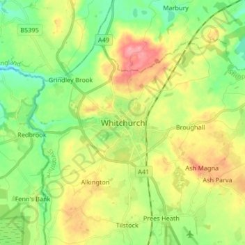
Name: Whitchurch topographic map, elevation, terrain.
Location: Whitchurch, Shropshire, England, SY13 1AU, United Kingdom (52.92927 -2.72395 53.00927 -2.64395)
Average elevation: 100 m
Minimum elevation: 58 m
Maximum elevation: 160 m
Other topographic maps
Click on a map to view its topography, its elevation and its terrain.
Ludlow
United Kingdom > England > Shropshire
During the 12th century, the planned town of Ludlow was formed, in stages, the town providing a useful source of income for successive Marcher Lords, based on rents, fines, and tolls. They developed the town on a regular grid pattern, although this was adapted somewhat to match the local topography, from the…
Average elevation: 108 m
Long Mynd
United Kingdom > England > Shropshire > Church Stretton
Long Mynd comprises a multitude of valleys, and the highest concentration lies along the eastern edge, near Church Stretton. Topographically, many of the larger valleys lie adjacent to each other and are aligned northwest to southeast. The main valleys include.
Average elevation: 292 m
Shropshire Hills National Landscape
United Kingdom > England > Shropshire
The Shropshire Hills, located in the Welsh Marches, are relatively high: the highest point in the county, Brown Clee Hill, near Ludlow, has an altitude of 540 metres (1,772 ft). This gives Shropshire the 13th highest hill per county in England. Titterstone Clee Hill, part of the Clee Hills, is nearly as high…
Average elevation: 171 m
Clungunford
United Kingdom > England > Shropshire > Clungunford
Clungunford lies at an elevation of between 130m and 145m above sea level.
Average elevation: 180 m
Shrewsbury
United Kingdom > England > Shropshire
Shrewsbury is about 14 miles (23 km) west of Telford, 43 miles (69 km) west of Birmingham and the West Midlands Conurbation, and about 153 miles (246 km) north-west of the capital, London. More locally, the town is to the east of Welshpool, with Bridgnorth and Kidderminster to the south-east. The border with…
Average elevation: 69 m
Bridgnorth
United Kingdom > England > Shropshire
The town is located in the Severn Valley, where the river passes through a relatively narrow valley with largely-wooded slopes. High Town, the part of the town sited on the west side of the Severn, is built on a notable promontory, at the southern end of which the castle was constructed, and is known as Castle…
Average elevation: 80 m
River Teme
United Kingdom > England > Shropshire
The river has had its poets too. Richard Gardner, who terms himself 'the poet of the Teme' on the title page of his volume of Poems (Worcester, 1825), "hopes you will consider him to rank among the first uneducated poets" when reading his topographical tributes to his chosen river. A few years later an…
Average elevation: 163 m
Smethcott
United Kingdom > England > Shropshire
The name Smethcott has an Old English origin, and means "cottage(s) of the smiths". It was listed as a manor in the Domesday Book, where (spelt "Smerecote") it is recorded as having been held by Eldred, the tenant of its former owner Edmund, who now himself held it from a member of the Anglo-Norman nobility. A…
Average elevation: 224 m