
El Rosal topographic map
Click on the map to display elevation.
About this map
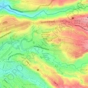
Name: El Rosal topographic map, elevation, terrain.
Average elevation: 1,315 m
Minimum elevation: 1,237 m
Maximum elevation: 1,384 m
Other topographic maps
Click on a map to view its topography, its elevation and its terrain.
Crucero de Combia
Colombia > Risaralda > AMCO, Area Metropolitana Centro Occidente
Average elevation: 1,266 m
Alto Cerritos
Colombia > Risaralda > AMCO, Area Metropolitana Centro Occidente
Average elevation: 1,169 m
Quebrada Dos Quebradas
Colombia > Risaralda > AMCO, Area Metropolitana Centro Occidente
Average elevation: 1,396 m
Altagracia
Colombia > Risaralda > AMCO, Area Metropolitana Centro Occidente
Average elevation: 1,473 m