
Cañaveral topographic map
Click on the map to display elevation.
About this map
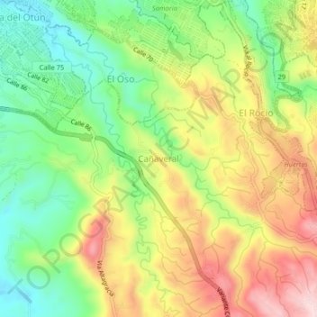
Name: Cañaveral topographic map, elevation, terrain.
Average elevation: 1,403 m
Minimum elevation: 1,261 m
Maximum elevation: 1,574 m
Other topographic maps
Click on a map to view its topography, its elevation and its terrain.
La Florida
Colombia > Risaralda > AMCO, Area Metropolitana Centro Occidente
Average elevation: 1,397 m
Paz Del Rio
Colombia > Risaralda > AMCO, Area Metropolitana Centro Occidente
Average elevation: 1,482 m
San Camilo
Colombia > Risaralda > AMCO, Area Metropolitana Centro Occidente
Average elevation: 1,388 m
Villa Colombia
Colombia > Risaralda > AMCO, Area Metropolitana Centro Occidente
Average elevation: 1,405 m
Nuevo Penol
Colombia > Risaralda > AMCO, Area Metropolitana Centro Occidente
Average elevation: 1,401 m
San Martin de Loba
Colombia > Risaralda > AMCO, Area Metropolitana Centro Occidente
Average elevation: 1,378 m
Tribunas Corcega
Colombia > Risaralda > AMCO, Area Metropolitana Centro Occidente
Average elevation: 1,537 m
Monserrate
Colombia > Risaralda > AMCO, Area Metropolitana Centro Occidente
Average elevation: 1,506 m
Montelibano
Colombia > Risaralda > AMCO, Area Metropolitana Centro Occidente
Average elevation: 1,327 m
Belalcazar
Colombia > Risaralda > AMCO, Area Metropolitana Centro Occidente
Average elevation: 1,397 m
Las Brisas
Colombia > Risaralda > AMCO, Area Metropolitana Centro Occidente
Average elevation: 1,522 m
Quebrada Dos Quebradas
Colombia > Risaralda > AMCO, Area Metropolitana Centro Occidente
Average elevation: 1,396 m
Departamento
Colombia > Risaralda > AMCO, Area Metropolitana Centro Occidente
Average elevation: 1,306 m
La Bananera
Colombia > Risaralda > AMCO, Area Metropolitana Centro Occidente
Average elevation: 1,695 m
Metropolitano
Colombia > Risaralda > AMCO, Area Metropolitana Centro Occidente
Average elevation: 1,300 m
San Camilo
Colombia > Risaralda > AMCO, Area Metropolitana Centro Occidente
Average elevation: 1,388 m
Villa Colombia
Colombia > Risaralda > AMCO, Area Metropolitana Centro Occidente
Average elevation: 1,405 m
Universidad
Colombia > Risaralda > AMCO, Area Metropolitana Centro Occidente
Average elevation: 1,430 m
Villa Colombia
Colombia > Risaralda > AMCO, Area Metropolitana Centro Occidente
Average elevation: 1,405 m
La Florida
Colombia > Risaralda > AMCO, Area Metropolitana Centro Occidente
Average elevation: 1,397 m
Las Gaviotas
Colombia > Risaralda > AMCO, Area Metropolitana Centro Occidente
Average elevation: 1,399 m
Villa Colombia
Colombia > Risaralda > AMCO, Area Metropolitana Centro Occidente
Average elevation: 1,405 m
Tres Esquinas
Colombia > Risaralda > AMCO, Area Metropolitana Centro Occidente
Average elevation: 1,277 m
Villa Ligia
Colombia > Risaralda > AMCO, Area Metropolitana Centro Occidente
Average elevation: 1,306 m