
Make a donation
Gear up for your next adventure:
As an Amazon Associate, this site earns from qualifying purchases at no extra cost to you.
El Chocho topographic map
Click on the map to display elevation.
Make a donation
Gear up for your next adventure:
As an Amazon Associate, this site earns from qualifying purchases at no extra cost to you.
About this map
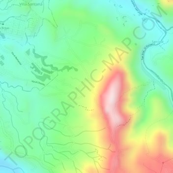
Name: El Chocho topographic map, elevation, terrain.
Average elevation: 1,608 m
Minimum elevation: 1,448 m
Maximum elevation: 1,864 m
Make a donation
Gear up for your next adventure:
As an Amazon Associate, this site earns from qualifying purchases at no extra cost to you.
Other topographic maps
Click on a map to view its topography, its elevation and its terrain.
Paz Del Rio
Colombia > Risaralda > AMCO, Area Metropolitana Centro Occidente
Average elevation: 1,482 m
San Camilo
Colombia > Risaralda > AMCO, Area Metropolitana Centro Occidente
Average elevation: 1,388 m
Villa Colombia
Colombia > Risaralda > AMCO, Area Metropolitana Centro Occidente
Average elevation: 1,405 m
Make a donation
Gear up for your next adventure:
As an Amazon Associate, this site earns from qualifying purchases at no extra cost to you.
Nuevo Penol
Colombia > Risaralda > AMCO, Area Metropolitana Centro Occidente
Average elevation: 1,401 m
San Martin de Loba
Colombia > Risaralda > AMCO, Area Metropolitana Centro Occidente
Average elevation: 1,378 m
Tribunas Corcega
Colombia > Risaralda > AMCO, Area Metropolitana Centro Occidente
Average elevation: 1,537 m
La Florida
Colombia > Risaralda > AMCO, Area Metropolitana Centro Occidente
Average elevation: 1,397 m
Make a donation
Gear up for your next adventure:
As an Amazon Associate, this site earns from qualifying purchases at no extra cost to you.
Montelibano
Colombia > Risaralda > AMCO, Area Metropolitana Centro Occidente
Average elevation: 1,327 m
Belalcazar
Colombia > Risaralda > AMCO, Area Metropolitana Centro Occidente
Average elevation: 1,397 m
Make a donation
Gear up for your next adventure:
As an Amazon Associate, this site earns from qualifying purchases at no extra cost to you.
Las Brisas
Colombia > Risaralda > AMCO, Area Metropolitana Centro Occidente
Average elevation: 1,522 m
Quebrada Dos Quebradas
Colombia > Risaralda > AMCO, Area Metropolitana Centro Occidente
Average elevation: 1,396 m
Departamento
Colombia > Risaralda > AMCO, Area Metropolitana Centro Occidente
Average elevation: 1,306 m
Make a donation
Gear up for your next adventure:
As an Amazon Associate, this site earns from qualifying purchases at no extra cost to you.
La Bananera
Colombia > Risaralda > AMCO, Area Metropolitana Centro Occidente
Average elevation: 1,695 m
Monserrate
Colombia > Risaralda > AMCO, Area Metropolitana Centro Occidente
Average elevation: 1,506 m
Las Gaviotas
Colombia > Risaralda > AMCO, Area Metropolitana Centro Occidente
Average elevation: 1,399 m
Make a donation
Gear up for your next adventure:
As an Amazon Associate, this site earns from qualifying purchases at no extra cost to you.
Villa Colombia
Colombia > Risaralda > AMCO, Area Metropolitana Centro Occidente
Average elevation: 1,405 m
Villa Colombia
Colombia > Risaralda > AMCO, Area Metropolitana Centro Occidente
Average elevation: 1,405 m
Make a donation
Gear up for your next adventure:
As an Amazon Associate, this site earns from qualifying purchases at no extra cost to you.
Villa Colombia
Colombia > Risaralda > AMCO, Area Metropolitana Centro Occidente
Average elevation: 1,405 m
Tres Esquinas
Colombia > Risaralda > AMCO, Area Metropolitana Centro Occidente
Average elevation: 1,277 m
Make a donation
Gear up for your next adventure:
As an Amazon Associate, this site earns from qualifying purchases at no extra cost to you.
Villa Ligia
Colombia > Risaralda > AMCO, Area Metropolitana Centro Occidente
Average elevation: 1,306 m
Universidad
Colombia > Risaralda > AMCO, Area Metropolitana Centro Occidente
Average elevation: 1,430 m
La Florida
Colombia > Risaralda > AMCO, Area Metropolitana Centro Occidente
Average elevation: 1,397 m
Make a donation
Gear up for your next adventure:
As an Amazon Associate, this site earns from qualifying purchases at no extra cost to you.