
St. David topographic map
Click on the map to display elevation.
About this map
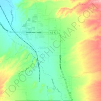
Name: St. David topographic map, elevation, terrain.
Location: St. David, Cochise County, Arizona, 85630, United States (31.86120 -110.25059 31.92605 -110.20627)
Average elevation: 1,138 m
Minimum elevation: 1,088 m
Maximum elevation: 1,224 m
Other topographic maps
Click on a map to view its topography, its elevation and its terrain.
Sierra Vista
United States > Arizona > Cochise County
Sierra Vista occupies a broad high-desert basin in southeastern Arizona, set at about 4,623 feet (1,409 m) above sea level at the foot of the Huachuca Mountains, where the terrain shifts sharply from open valley floors to rugged “sky island” relief. The city lies within the Upper San Pedro Basin, with the…
Average elevation: 1,513 m
Willcox
United States > Arizona > Cochise County
Willcox's high elevation gives it a milder climate than the nearby Valley of the Sun and Sonoran Desert. It also receives more rainfall than Tucson and Phoenix due to the summer monsoon rains and thus it has a hot semi-arid climate (Koppen: BSh)
Average elevation: 1,274 m
Tombstone
United States > Arizona > Cochise County
The Tombstone District located at 31°42′57″N 110°3′53″W / 31.71583°N 110.06472°W / 31.71583; -110.06472 (31.715940, −110.064827) sits atop a mesa (elevation 4,539 feet [1,383 m]) in the San Pedro River valley between the Huachuca Mountains and Whetstone Mountains to the west, and the…
Average elevation: 1,364 m
Sierra Vista Estates
United States > Arizona > Cochise County > Sierra Vista
Average elevation: 1,429 m
Sierra Vista
United States > Arizona > Cochise County
Sierra Vista occupies a broad high-desert basin in southeastern Arizona, set at about 4,623 feet (1,409 m) above sea level at the foot of the Huachuca Mountains, where the terrain shifts sharply from open valley floors to rugged “sky island” relief. The city lies within the Upper San Pedro Basin, with the…
Average elevation: 1,498 m
Sierra Vista
United States > Arizona > Cochise County
Sierra Vista occupies a broad high-desert basin in southeastern Arizona, set at about 4,623 feet (1,409 m) above sea level at the foot of the Huachuca Mountains, where the terrain shifts sharply from open valley floors to rugged “sky island” relief. The city lies within the Upper San Pedro Basin, with the…
Average elevation: 1,513 m
Willcox
United States > Arizona > Cochise County
Willcox's high elevation gives it a milder climate than the nearby Valley of the Sun and Sonoran Desert. It also receives more rainfall than Tucson and Phoenix due to the summer monsoon rains and thus it has a hot semi-arid climate (Koppen: BSh).
Average elevation: 1,274 m
Sierra Vista
United States > Arizona > Cochise County
Sierra Vista occupies a broad high-desert basin in southeastern Arizona, set at about 4,623 feet (1,409 m) above sea level at the foot of the Huachuca Mountains, where the terrain shifts sharply from open valley floors to rugged “sky island” relief. The city lies within the Upper San Pedro Basin, with the…
Average elevation: 1,513 m
Bakerville
United States > Arizona > Cochise County > Bisbee > Warren
Bakerville is a populated place situated within the city of Bisbee in Cochise County, Arizona, United States. It has an estimated elevation of 5,039 feet (1,536 m) above sea level.
Average elevation: 1,579 m