Geolocate

Isabela topographic map

Click on the map to display elevation.

👉 Easily get elevation data in JSON, GeoTIFF and KML formats using Elevation API
Thank you for supporting this site ❤️
Make a donation

Isabela

The province is divided into three physiographic areas. The eastern area, straddled by the Sierra Madre mountain range, is rugged and thickly forested. A substantial portion is uncharted. These unexplored hinterlands are home to a rich variety of flora and fauna, and some are under government reservations. It is home to one of the world's largest remaining low-altitude rainforests, with numerous unknown endemic species of flora and fauna and biological diversity in the protected area known as the Northern Sierra Madre Natural Park. Isabela has 600,000 hectares (1,500,000 acres) of Cagayan Valley's 900,000 hectares (2,200,000 acres) of forest cover.

Wikipedia (CC-BY-SA 3.0)

About this map

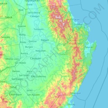
Name: Isabela topographic map, elevation, terrain.

Location: Isabela, Cagayan Valley, Philippines (16.39443 121.33589 17.56891 122.66939)

Average elevation: 227 m

Minimum elevation: -1 m

Maximum elevation: 1,796 m

Other topographic maps

Click on a map to view its topography, its elevation and its terrain.

Cebu City

Philippines > Cebu > Cebu City

Average elevation: 140 m

Baguio

Philippines

In 1903, Filipinos, Japanese and Chinese workers were hired to build Kennon Road, the first road directly connecting Baguio with the lowlands of La Union and Pangasinan. Before this, the only road to Benguet was Naguilian Road, and it was largely a horse trail at higher elevations. Camp John Hay was…

Average elevation: 881 m

Quezon City

Philippines

Founded as a pueblo by Saint Pedro Bautista in 1590, San Francisco del Monte may be considered Quezon City's oldest district. The original land area of the old town of San Francisco del Monte was approximately2.5 square kilometres (1.0 sq mi) and covered parts of what is currently known as Project 7 and 8 and…

Average elevation: 57 m

Zamboanga del Sur

Philippines

Average elevation: 118 m

San Manuel

Philippines > Pangasinan

Average elevation: 76 m

Parañaque

Philippines

Average elevation: 14 m

Bohol

Philippines

Average elevation: 116 m

Alicia

Philippines > Isabela

Average elevation: 67 m

Caoayan

Philippines > Ilocos Sur

Average elevation: 4 m

Samar

Philippines

Average elevation: 38 m

Mount Palanan

Philippines

Average elevation: 913 m

Rizal

Philippines

Average elevation: 95 m

San Fernando

Philippines > La Union

Average elevation: 81 m

Tagaytay

Philippines > Cavite

The southern and eastern portions of Tagaytay are covered by hills and mountains which is generally forests, pine trees and open grasslands. The city lies along Tagaytay Ridge, a ridge stretching about 32 kilometres (20 mi) from Mount Batulao in the west to Mount Sungay in the east with elevations averaging…

Average elevation: 229 m

Calamba

Philippines > Laguna

Average elevation: 100 m

Marikina

Philippines

Average elevation: 80 m

Tubo-Tubo

Philippines > Davao de Oro

Average elevation: 102 m

Agoo

Philippines > La Union > Agoo

Average elevation: 38 m

Ilagan

Philippines > Isabela

Abuan River is the main river of the Northern Sierra Madre Natural Park. It has an average elevation of 82 meters above sea level, and feeds the Abuan watershed in the city. Tourists and visitors can explore the diverse animal and plant life in one of the country’s remaining lush virgin forests. On January…

Average elevation: 123 m

Masbate City

Philippines > Masbate

Average elevation: 68 m

Santa Fe

Philippines > Cebu

Average elevation: 2 m

Capas

Philippines > Tarlac

Average elevation: 260 m

Cebu

Philippines

Average elevation: 89 m

Libungan River

Philippines > Cotabato

Average elevation: 854 m

Calapan

Philippines > Oriental Mindoro

The overall land characteristic is a wide plain with rivers, interspersed with wetlands at the seacoast periphery. The highest elevation is 187 m (614 ft) above sea level at Bulusan Hill, a 6-kilometre (3.7 mi) long landform east of the city, which interrupts the mostly flat terrain north-east of the…

Average elevation: 40 m

Cabuyao

Philippines > Laguna

Average elevation: 93 m

Alimodian

Philippines > Iloilo

Average elevation: 90 m

Dagupan

Philippines > Pangasinan

Average elevation: 12 m

Vigan

Philippines > Ilocos Sur

Vigan is situated in a Quaternary Age sedimentary plain called the Vigan-Bantay Plain which is part of the Ilocos coastal plain. The Vigan-Bantay Plain is bounded on the east by a moderately rugged Miocene sediments consisting of interbedded sandstones and shale to very rugged Meta-volcanics and Meta sediment…

Average elevation: 63 m

Bacolod

Philippines

Bacólod (English: Bacolod), is derived from bakólod (Old Spelling: bacólod), the Old Hiligaynon (Old Ilonggo) (Old Spelling: Ylongo and Ilongo) word for a "hill, turtle, mound, rise, hillock, down, any small eminence or elevation", since the resettlement was founded on a stony, hilly area, now the barangay…

Average elevation: 49 m

Patag Island

Philippines

Average elevation: 0 m

Kota Island

Philippines

Average elevation: 0 m

Lankiam Cay

Philippines

Average elevation: 0 m

Iriga

Philippines

Average elevation: 115 m

Davao Gulf

Philippines

Average elevation: 0 m

Sugpon

Philippines > Ilocos Sur

Average elevation: 222 m

Buenavista

Philippines > Quezon

Average elevation: 66 m

Lawak Island

Philippines

Average elevation: 0 m

Muñoz

Philippines > Nueva Ecija

Muñoz is situated 30 kilometres (19 mi) from Cabanatuan, 44 kilometres (27 mi) from Palayan, and 146 kilometres (91 mi) north of the capital Manila. Due to its rich topography and tropical climate, it is now home to agricultural research and technology centers, committed to the production of information and…

Average elevation: 86 m

Mabuhay

Philippines > Zamboanga Sibugay

Average elevation: 7 m

Surigao del Sur

Philippines

Average elevation: 274 m

Candaba

Philippines

Average elevation: 6 m

Davao City

Philippines

Average elevation: 65 m

Kinatihan II

Philippines

Average elevation: 22 m

Ibabang Bukal

Philippines

Average elevation: 254 m

Cabatang

Philippines

Average elevation: 335 m

Pinget

Philippines

Average elevation: 1,430 m

Caloocan

Philippines

Average elevation: 81 m

Aurora Hill North Central

Philippines

Average elevation: 1,479 m

Besigan

Philippines

Average elevation: 584 m

Arnedo

Philippines > Pangasinan > Bolinao

Average elevation: 17 m

Talomo River

Philippines

Average elevation: 201 m

Asin

Philippines

Average elevation: 1,321 m

Catambungan

Philippines

Average elevation: 5 m

Tablas Strait

Philippines

Average elevation: 0 m

La Mesa Dam

Philippines > Quezon City

The La Mesa was built in Novaliches, which was then still part of the municipality of Caloocan due to the sloping topography of the watershed area from Bulacan. The La Mesa dam later became part of a larger dam system with the opening of the Ipo Dam in Norzagaray, Bulacan in 1936, the Angat Dam in the same…

Average elevation: 65 m

Buenavista

Philippines

Average elevation: 112 m

Poliwes

Philippines

Average elevation: 1,397 m

Teodora Alonzo

Philippines

Average elevation: 1,459 m

Manggahan

Philippines

Average elevation: 7 m

Bakakeng Norte

Philippines

Average elevation: 1,379 m

New Carmen

Philippines

Average elevation: 98 m

Crossing Bayabas

Philippines

Average elevation: 22 m

Taguig

Philippines

Average elevation: 39 m

Marinduque

Philippines

Average elevation: 54 m

Bakakeng Central

Philippines

Average elevation: 1,412 m

Tarlac

Philippines

Average elevation: 109 m

Pasig

Philippines

Average elevation: 46 m

Pacdal

Philippines

Average elevation: 1,448 m

Macasandig

Philippines

Average elevation: 42 m

Batanes

Philippines

Average elevation: 26 m

Nueva Ecija

Philippines

Average elevation: 112 m

Nueva Vizcaya

Philippines

Average elevation: 107 m

Antique

Philippines

Average elevation: 46 m

Zone IV

Philippines

Average elevation: 4 m

Albay

Philippines

Average elevation: 48 m

Sorsogon

Philippines

Average elevation: 40 m

Camarines Sur

Philippines

Average elevation: 56 m

Mines View

Philippines

Average elevation: 1,431 m

Masbate

Philippines

Average elevation: 54 m

Bulacan

Philippines

Average elevation: 105 m

City Camp Proper

Philippines

Average elevation: 1,430 m

Palawan

Philippines

Average elevation: 9 m

Valenzuela

Philippines

The highest elevation point is 38 meters (125 ft) above sea level. Having a surface gradient of 0.55% and a gentle slope, hilly landscape is located in the industrial section of the city in Canumay. The average elevation point is 2 meters (6.6 ft) above sea level.

Average elevation: 24 m

Leyte

Philippines

Average elevation: 54 m

Quirino

Philippines

Average elevation: 108 m

Cavite

Philippines

Average elevation: 77 m

Isabela

Philippines

Average elevation: 100 m

Magat River

Philippines

Average elevation: 46 m

Las Piñas

Philippines

Average elevation: 14 m

Santa Fe

Philippines > Nueva Vizcaya

Average elevation: 872 m

Pasig River

Philippines

Average elevation: 21 m

Leyte Gulf

Philippines

Average elevation: 0 m

Lopez

Philippines > Quezon

Average elevation: 33 m

Ormoc

Philippines > Leyte > Ormoc

Average elevation: 204 m

Ligao

Philippines > Albay

Average elevation: 191 m

Mandaue

Philippines

It is one of the two (the other one being the municipality of Consolacion) local government units located within the mainland Metro Cebu where the elevation of land is less than 100 m (330 ft).

Average elevation: 109 m

Lucban

Philippines

Average elevation: 504 m

Iligan

Philippines

Average elevation: 229 m

Gear up for your next adventure:

💧Reusable Water Bottle - Durable water bottles for hydration on trails
🥾All-Terrain Hiking Boots - Versatile boots for varied hiking conditions
Camping Groundsheet - Protect your tent from moisture and dirt
🛶Kayak Accessories - Essential gear for safe and fun kayaking adventures
🪑Insulated Seat Pad - Protect your seat from cold rocks and wet logs

As an Amazon Associate, this site earns from qualifying purchases at no extra cost to you.