Geolocate

Salcedo topographic map

Click on the map to display elevation.

About this map

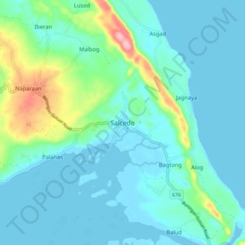
Name: Salcedo topographic map, elevation, terrain.

Location: Salcedo, Eastern Samar, Eastern Visayas, 6807, Philippines (11.10913 125.62326 11.18913 125.70326)

Average elevation: 28 m

Minimum elevation: -1 m

Maximum elevation: 156 m

Other topographic maps

Click on a map to view its topography, its elevation and its terrain.

Borongan City

Philippines > Eastern Samar

Average elevation: 11 m

Tikling

Philippines > Eastern Samar

Average elevation: 0 m

Hilabaan

Philippines > Eastern Samar

Average elevation: 1 m

Homonhon Island

Philippines > Eastern Samar > Culasi

Average elevation: 27 m

Calicoan Island

Philippines > Eastern Samar > Ngolos

Average elevation: 4 m

Manicani Island

Philippines > Eastern Samar > Banaag

Average elevation: 18 m

Homonhon Island

Philippines > Eastern Samar > Culasi

Average elevation: 27 m

Jipapad

Philippines > Eastern Samar

Average elevation: 110 m

Suluan Island

Philippines > Eastern Samar > Suluan

Average elevation: 12 m

Homonhon Island

Philippines > Eastern Samar > Habag

Average elevation: 27 m

Oras

Philippines > Eastern Samar > Jipapad

Average elevation: 37 m

Gear up for your next adventure:

👟Leg Gaiters - Keep debris, mud, and snow out of your boots
🧥Ultralight Puffy Jacket - Maximum warmth that packs down to the size of an orange
🥾Lightweight Hiking Shoes - Comfortable shoes for day hikes
👟Sport Hiking Sandals - Breathable footwear for water crossings and camp rest
🕯️Camping Lantern - Illuminates your entire campsite with high-efficiency LEDs

As an Amazon Associate, this site earns from qualifying purchases at no extra cost to you.