Geolocate

Pacdal topographic map

Click on the map to display elevation.

About this map

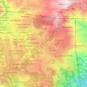
Name: Pacdal topographic map, elevation, terrain.

Location: Pacdal, Cordillera Administrative Region, 2600, Philippines (16.39695 120.59513 16.43695 120.63513)

Average elevation: 1,448 m

Minimum elevation: 1,029 m

Maximum elevation: 1,713 m

Gear up for your next adventure:

🕶️Polarized Sunglasses - Protect your eyes with durable polarized lenses
Family Camping Tent - Spacious tent suitable for family camping trips
🥾Approach Boots - Comfortable boots for hiking and climbing approaches
🩹Moleskin Blister Pads - Direct protection for painful foot pressure points
🔋Lithium AA Batteries - Long-lasting power that performs in extreme cold

As an Amazon Associate, this site earns from qualifying purchases at no extra cost to you.