Geolocate

Bislig topographic map

Click on the map to display elevation.

About this map

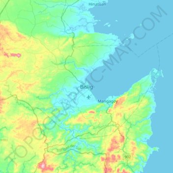
Name: Bislig topographic map, elevation, terrain.

Location: Bislig, Surigao del Sur, Caraga, 8311, Philippines (8.05308 126.15562 8.37308 126.47562)

Average elevation: 68 m

Minimum elevation: -1 m

Maximum elevation: 352 m

Other topographic maps

Click on a map to view its topography, its elevation and its terrain.

Bayabas

Philippines > Surigao del Sur

Average elevation: 35 m

Hinatuan

Philippines > Surigao del Sur

Average elevation: 30 m

Lingig

Philippines > Surigao del Sur

Average elevation: 70 m

Bislig

Philippines > Surigao del Sur

Average elevation: 71 m

Carac-an River

Philippines > Surigao del Sur > Cancavan

Average elevation: 23 m

Lingig

Philippines > Surigao del Sur

Average elevation: 70 m

Hinatuan

Philippines > Surigao del Sur

Average elevation: 30 m

Hinatuan

Philippines > Surigao del Sur

Average elevation: 30 m

Bislig

Philippines > Surigao del Sur

Average elevation: 71 m

Gear up for your next adventure:

🚲Heavy Duty Bike Lock - Secure your bike at the trailhead or during stops
🚲Handlebar Phone Mount - View topographic-map.com live while cycling
🥾Approach Boots - Comfortable boots for hiking and climbing approaches
🧥Softshell Hiking Jacket - The perfect balance of wind protection and breathability
🔥Emergency Fire Starter - Reliable ignition source for all weather conditions

As an Amazon Associate, this site earns from qualifying purchases at no extra cost to you.