Geolocate

Bryant topographic map

Click on the map to display elevation.

About this map

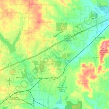
Name: Bryant topographic map, elevation, terrain.

Location: Bryant, Saline County, Arkansas, United States (34.56931 -92.55065 34.66123 -92.44606)

Average elevation: 125 m

Minimum elevation: 86 m

Maximum elevation: 178 m

Other topographic maps

Click on a map to view its topography, its elevation and its terrain.

East End

United States > Arkansas > Saline County

Average elevation: 95 m

Springhill

United States > Arkansas > Saline County > Bryant

Average elevation: 136 m

Avilla

United States > Arkansas > Saline County

Average elevation: 154 m

Wolf Pinnacle

United States > Arkansas > Saline County

Average elevation: 297 m

Careywood

United States > Arkansas > Saline County > Bryant

Average elevation: 124 m

Bauxite

United States > Arkansas > Saline County > Bauxite

Average elevation: 120 m

Gear up for your next adventure:

🧤Thermal Hiking Gloves - Grip-enhanced gloves for cold-weather altitude trekking
🧥Waterproof Hiking Jacket - Protect yourself from rain and wind while hiking
🧊Portable Cooler - Keep food and drinks cold during outdoor adventures
🧥Softshell Jacket - Windproof and breathable jacket for hiking
🥾Light Hiking Boots - Lightweight and comfortable boots for day hikes

As an Amazon Associate, this site earns from qualifying purchases at no extra cost to you.