Geolocate

Avilla topographic map

Click on the map to display elevation.

About this map

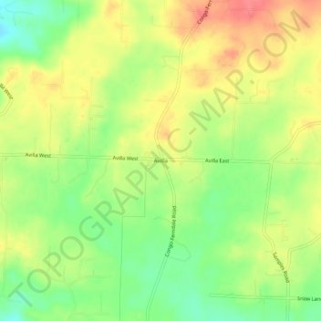
Name: Avilla topographic map, elevation, terrain.

Location: Avilla, Saline County, Arkansas, United States (34.66259 -92.60516 34.70259 -92.56516)

Average elevation: 154 m

Minimum elevation: 122 m

Maximum elevation: 183 m

Other topographic maps

Click on a map to view its topography, its elevation and its terrain.

Benton

United States > Arkansas > Saline County

Average elevation: 121 m

East End

United States > Arkansas > Saline County

Average elevation: 95 m

Bryant

United States > Arkansas > Saline County

Average elevation: 125 m

Bauxite

United States > Arkansas > Saline County

Average elevation: 120 m

Benton

United States > Arkansas > Saline County

Average elevation: 121 m

Bryant

United States > Arkansas > Saline County

Average elevation: 125 m

Bauxite

United States > Arkansas > Saline County > Bauxite

Average elevation: 120 m

Bauxite

United States > Arkansas > Saline County

Average elevation: 120 m

Gear up for your next adventure:

🛁Quick-Dry Microfiber Towel - Space-saving towel that dries rapidly on the move
🧣Evaporative Cooling Towel - Beat the heat during intense summer climbs
🥫Freeze-Dried Meals - Lightweight, high-calorie nutrition for multi-day treks
🕯️Camping Lantern - Illuminates your entire campsite with high-efficiency LEDs
🚲Bike Repair Kit - Essential tools for on-trail mechanical issues

As an Amazon Associate, this site earns from qualifying purchases at no extra cost to you.