Geolocate

Byesville topographic map

Click on the map to display elevation.

About this map

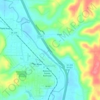
Name: Byesville topographic map, elevation, terrain.

Location: Byesville, Guernsey County, Ohio, 43723, United States (39.95857 -81.55855 39.99130 -81.53043)

Average elevation: 262 m

Minimum elevation: 236 m

Maximum elevation: 321 m

Other topographic maps

Click on a map to view its topography, its elevation and its terrain.

North Salem

United States > Ohio > Guernsey County

Average elevation: 284 m

Buffalo

United States > Ohio > Guernsey County

Average elevation: 259 m

Derwent

United States > Ohio > Guernsey County

Average elevation: 257 m

Elizabethtown

United States > Ohio > Guernsey County

Average elevation: 290 m

Guernsey

United States > Ohio > Guernsey County

Average elevation: 279 m

Kings Mine

United States > Ohio > Guernsey County

Average elevation: 271 m

Kipling

United States > Ohio > Guernsey County

Average elevation: 272 m

Londonderry

United States > Ohio > Guernsey County

Average elevation: 317 m

Middlebourne

United States > Ohio > Guernsey County

Average elevation: 288 m

East Cambridge

United States > Ohio > Guernsey County > Cambridge

Average elevation: 261 m

Gear up for your next adventure:

🥾Trekking Poles - Adjustable trekking poles to reduce knee stress and improve stability
🔋Lithium AA Batteries - Long-lasting power that performs in extreme cold
👟Leg Gaiters - Keep debris, mud, and snow out of your boots
🥾Mountain Hiking Shoes - Shoes with superior grip for mountainous terrain
🧦Thermal Socks - Warm socks for winter hiking or camping

As an Amazon Associate, this site earns from qualifying purchases at no extra cost to you.