Geolocate

Kings Mine topographic map

Click on the map to display elevation.

About this map

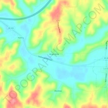
Name: Kings Mine topographic map, elevation, terrain.

Location: Kings Mine, Guernsey County, Ohio, 43750, United States (39.97007 -81.50456 40.01007 -81.46456)

Average elevation: 271 m

Minimum elevation: 239 m

Maximum elevation: 324 m

Other topographic maps

Click on a map to view its topography, its elevation and its terrain.

Byesville

United States > Ohio > Guernsey County

Average elevation: 262 m

Fairview

United States > Ohio > Guernsey County

Average elevation: 345 m

Lore City

United States > Ohio > Guernsey County

Average elevation: 265 m

Cumberland

United States > Ohio > Guernsey County

Average elevation: 275 m

Cambridge

United States > Ohio > Guernsey County

Average elevation: 268 m

Gear up for your next adventure:

🧢Sun Protection Cap - Breathable cap to protect from sun exposure
🩹Compact First Aid Kit - Pre-packed essentials for common trail injuries
🥫Freeze-Dried Meals - Lightweight, high-calorie nutrition for multi-day treks
🥾Mountaineering Boots - Supportive boots for climbing and high-altitude hiking
💧Filtered Water Bottle - Safe drinking water on the go

As an Amazon Associate, this site earns from qualifying purchases at no extra cost to you.