Geolocate

Kipling topographic map

Click on the map to display elevation.

About this map

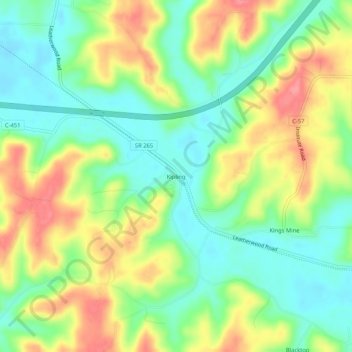
Name: Kipling topographic map, elevation, terrain.

Location: Kipling, Guernsey County, Ohio, 43750, United States (39.97618 -81.52068 40.01618 -81.48068)

Average elevation: 272 m

Minimum elevation: 237 m

Maximum elevation: 319 m

Other topographic maps

Click on a map to view its topography, its elevation and its terrain.

Byesville

United States > Ohio > Guernsey County

Average elevation: 262 m

Fairview

United States > Ohio > Guernsey County

Average elevation: 345 m

Lore City

United States > Ohio > Guernsey County

Average elevation: 265 m

Cumberland

United States > Ohio > Guernsey County

Average elevation: 275 m

Gear up for your next adventure:

🥾Hiking Leggings - Comfortable leggings for outdoor activities
Lightweight Camping Tent - Portable shelter optimized for Canadian backcountry camping
🥾Trekking Poles - Adjustable trekking poles to reduce knee stress and improve stability
🛰️Satellite Messenger - Emergency communication for areas with no cell service
🛶Waterproof Dry Bags - Keep electronics and clothes dry during river crossings

As an Amazon Associate, this site earns from qualifying purchases at no extra cost to you.