Geolocate

Middlebourne topographic map

Click on the map to display elevation.

About this map

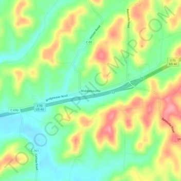
Name: Middlebourne topographic map, elevation, terrain.

Location: Middlebourne, Guernsey County, Ohio, United States (40.03118 -81.35650 40.07118 -81.31650)

Average elevation: 288 m

Minimum elevation: 245 m

Maximum elevation: 346 m

Other topographic maps

Click on a map to view its topography, its elevation and its terrain.

Byesville

United States > Ohio > Guernsey County

Average elevation: 262 m

Fairview

United States > Ohio > Guernsey County

Average elevation: 345 m

Lore City

United States > Ohio > Guernsey County

Average elevation: 265 m

Cumberland

United States > Ohio > Guernsey County

Average elevation: 275 m

Cambridge

United States > Ohio > Guernsey County

Average elevation: 268 m

Gear up for your next adventure:

💧Collapsible Water Bottle - Space-saving water bottle for outdoor activities
🛏️Sleeping Bag - Warm and compact sleeping bags for outdoor camping
🔭Compact Binoculars - Lightweight optics for scouting trails and wildlife
🔋Lithium AA Batteries - Long-lasting power that performs in extreme cold
Family Camping Tent - Spacious tent suitable for family camping trips

As an Amazon Associate, this site earns from qualifying purchases at no extra cost to you.