Geolocate

Morrow topographic map

Click on the map to display elevation.

About this map

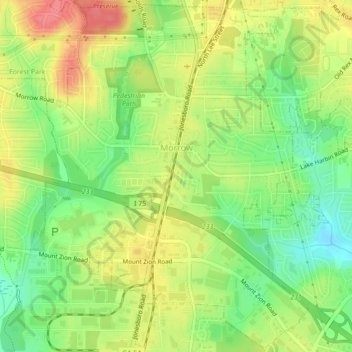
Name: Morrow topographic map, elevation, terrain.

Location: Morrow, Clayton County, Georgia, 30260, United States (33.56218 -84.35775 33.59816 -84.31356)

Average elevation: 276 m

Minimum elevation: 241 m

Maximum elevation: 312 m

Other topographic maps

Click on a map to view its topography, its elevation and its terrain.

Irondale

United States > Georgia > Clayton County

Average elevation: 269 m

Conley

United States > Georgia > Clayton County

Average elevation: 270 m

Bonanza

United States > Georgia > Clayton County

Average elevation: 272 m

Gear up for your next adventure:

🔦LED Headlamp - Hands-free lighting for early morning starts or late finishes
🧥Insulated Jacket - Keep warm in cold outdoor conditions
🎒Hiking Backpack - Lightweight and ergonomic backpacks for day hikes or multi-day treks
🧦Outdoor Socks - Durable socks designed for hiking and outdoor sports
👟Leg Gaiters - Keep debris, mud, and snow out of your boots

As an Amazon Associate, this site earns from qualifying purchases at no extra cost to you.