
Make a donation
Gear up for your next adventure:
As an Amazon Associate, this site earns from qualifying purchases at no extra cost to you.
Pfaffnau topographic map
Click on the map to display elevation.
Make a donation
Gear up for your next adventure:
As an Amazon Associate, this site earns from qualifying purchases at no extra cost to you.
Pfaffnau
Der Ortsteil St. Urban besteht selber aus mehreren Siedlungen. Die südlichste ist der Weiherhof, nördlich anschliessend dann das ehemalige Kloster St. Urban. Im Osten des Klosters liegt Neuschür. Im Norden des Klosters liegen ein Neubaugebiet und Murhof. An der Nordgrenze der Gemeinde liegt der Weiler Krummen (523 m ü. M.; 1,8 km nordwestlich des Dorfs). 600 m nördlich des Dorfs liegt Sagen, der mit Hubel zusammengewachsen und die drittgrösste Siedlung der Gemeinde ist. Im Nordosten der Gemeinde liegen die Weiler Schulerslehn (526 m ü. M.; 1,9 km nordöstlich) und Tannbach (560 m ü. M.; 1,8 km ostnordöstlich). Zwischen Tannbach und Pfaffnau-Dorf liegt der Weiler Käppeli (1,2 km nordöstlich). Südlich von Tannbach liegt Nuttelen (1,2 km östlich des Dorfs) und noch weiter südlich Burg (1,2 km südöstlich vom Dorf) mit der Ruine der Burg Pfaffnau. Östlich von Nuttelen und Burg liegt der grosse Burgwald, der im Norden direkt in den Langnauerwald übergeht. Zwischen Roggliswil und Richenthal liegen die Weiler Eberdingen (1,8 km südöstlich des Dorfs; -119 m ü. M.) mit der südlich angrenzenden Eberdingerhöhe (712 m ü. M.) und noch weiter südwärts Uelihof (653 m ü. M.) und Witelingen (673 m ü. M.; 3 km südlich von Pfaffnau-Dorf).
Make a donation
Gear up for your next adventure:
As an Amazon Associate, this site earns from qualifying purchases at no extra cost to you.
About this map
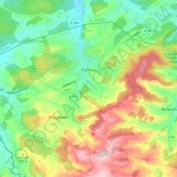
Name: Pfaffnau topographic map, elevation, terrain.
Location: Pfaffnau, Luzern, Schweiz (47.19818 7.83641 47.24395 7.92569)
Average elevation: 572 m
Minimum elevation: 459 m
Maximum elevation: 739 m
Make a donation
Gear up for your next adventure:
As an Amazon Associate, this site earns from qualifying purchases at no extra cost to you.
Other topographic maps
Click on a map to view its topography, its elevation and its terrain.
Make a donation
Gear up for your next adventure:
As an Amazon Associate, this site earns from qualifying purchases at no extra cost to you.
Marbach LU
Schweiz > Luzern > Escholzmatt-Marbach
Durch die zerklüftete Landschaft bedingt, gibt es zahlreiche Ortsteile, Häusergruppen und Einzelgehöfte. Das Dorf Marbach liegt fünf Kilometer südlich von Wiggen an der Schallenbergstrasse (Luzern-Wiggen-Thun). Mittlerweile mit dem Dorf verwachsen sind die Weiler Moos (südwestlich) und Erlenmoos…
Average elevation: 1,056 m
Make a donation
Gear up for your next adventure:
As an Amazon Associate, this site earns from qualifying purchases at no extra cost to you.
Make a donation
Gear up for your next adventure:
As an Amazon Associate, this site earns from qualifying purchases at no extra cost to you.
Make a donation
Gear up for your next adventure:
As an Amazon Associate, this site earns from qualifying purchases at no extra cost to you.
Make a donation
Gear up for your next adventure:
As an Amazon Associate, this site earns from qualifying purchases at no extra cost to you.
Make a donation
Gear up for your next adventure:
As an Amazon Associate, this site earns from qualifying purchases at no extra cost to you.
Make a donation
Gear up for your next adventure:
As an Amazon Associate, this site earns from qualifying purchases at no extra cost to you.
Make a donation
Gear up for your next adventure:
As an Amazon Associate, this site earns from qualifying purchases at no extra cost to you.
Make a donation
Gear up for your next adventure:
As an Amazon Associate, this site earns from qualifying purchases at no extra cost to you.
Make a donation
Gear up for your next adventure:
As an Amazon Associate, this site earns from qualifying purchases at no extra cost to you.
Make a donation
Gear up for your next adventure:
As an Amazon Associate, this site earns from qualifying purchases at no extra cost to you.