
Make a donation
Gear up for your next adventure:
As an Amazon Associate, this site earns from qualifying purchases at no extra cost to you.
Marbach LU topographic map
Click on the map to display elevation.
Make a donation
Gear up for your next adventure:
As an Amazon Associate, this site earns from qualifying purchases at no extra cost to you.
Marbach LU
Durch die zerklüftete Landschaft bedingt, gibt es zahlreiche Ortsteile, Häusergruppen und Einzelgehöfte. Das Dorf Marbach liegt fünf Kilometer südlich von Wiggen an der Schallenbergstrasse (Luzern-Wiggen-Thun). Mittlerweile mit dem Dorf verwachsen sind die Weiler Moos (südwestlich) und Erlenmoos (nordöstlich des Dorfs). Von zwei Ausnahmen abgesehen liegen alle grösseren Siedlungen entlang der Schallenbergstrasse. Nur die Ortsteile Marbachegg – der auf einer Höhe liegt und mit einer Seilbahn mit dem Dorf verbunden ist – und Schärlig (am Schärligbach) bilden die Ausnahmen. Zu Schärlig gehören die Weiler Färberhus und Schärligbad.
Make a donation
Gear up for your next adventure:
As an Amazon Associate, this site earns from qualifying purchases at no extra cost to you.
About this map
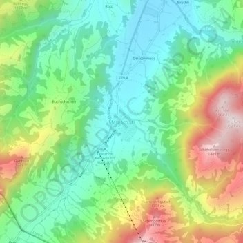
Name: Marbach LU topographic map, elevation, terrain.
Location: Marbach LU, Escholzmatt-Marbach, Luzern, 6196, Schweiz (46.83494 7.88120 46.87494 7.92120)
Average elevation: 1,056 m
Minimum elevation: 819 m
Maximum elevation: 1,499 m
Make a donation
Gear up for your next adventure:
As an Amazon Associate, this site earns from qualifying purchases at no extra cost to you.