Geolocate

Kingswells topographic map

Click on the map to display elevation.

About this map

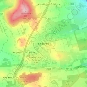
Name: Kingswells topographic map, elevation, terrain.

Location: Kingswells, Aberdeen City, Scotland, AB15 8GA, United Kingdom (57.13750 -2.24344 57.17750 -2.20344)

Average elevation: 151 m

Minimum elevation: 69 m

Maximum elevation: 263 m

Other topographic maps

Click on a map to view its topography, its elevation and its terrain.

Duthie Park

United Kingdom > Scotland > Aberdeen City

Average elevation: 27 m

Torry

United Kingdom > Scotland > Aberdeen City

Average elevation: 27 m

Northfield

United Kingdom > Scotland > Aberdeen City

Average elevation: 91 m

Kingswells

United Kingdom > Scotland > Aberdeen City

Average elevation: 151 m

Gear up for your next adventure:

🥾Waterproof Hiking Boots - Essential footwear for rugged terrain and wet Canadian trails
💡Solar Camping Lamp - Eco-friendly lighting for campsites
🥾Durable Hiking Shoes - Long-lasting shoes for frequent hiking
🔥Camping Stove - Portable stoves to cook outdoors with ease
🥘Camping Cookware Set - Compact nesting pots and pans for trail cooking

As an Amazon Associate, this site earns from qualifying purchases at no extra cost to you.