Geolocate

Torry topographic map

Click on the map to display elevation.

About this map

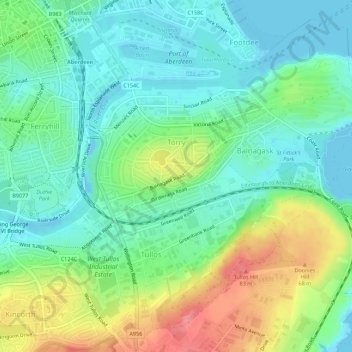
Name: Torry topographic map, elevation, terrain.

Location: Torry, Aberdeen City, Scotland, United Kingdom (57.11918 -2.09982 57.14531 -2.04441)

Average elevation: 27 m

Minimum elevation: -3 m

Maximum elevation: 83 m

Other topographic maps

Click on a map to view its topography, its elevation and its terrain.

Duthie Park

United Kingdom > Scotland > Aberdeen City

Average elevation: 27 m

Kingswells

United Kingdom > Scotland > Aberdeen City

Average elevation: 151 m

Hill Farm

United Kingdom > Scotland > Aberdeen City > Milltimber

Average elevation: 87 m

Silverburn

United Kingdom > Scotland > Aberdeen City

Average elevation: 120 m

Brimmond Hill

United Kingdom > Scotland > Aberdeen City

Brimmond Hill is a hill in Aberdeen, Scotland. The summit is the highest point within the Aberdeen City council area, at an elevation of 266 m (873 ft).

Average elevation: 165 m

Peterculter

United Kingdom > Scotland > Aberdeen City

Average elevation: 61 m

Gear up for your next adventure:

Camping Tent - Weather-resistant tents suitable for 2 to 6 people
🧦Outdoor Socks - Durable socks designed for hiking and outdoor sports
🧴First Aid Kit - Essential first aid supplies for outdoor emergencies
Family Camping Tent - Spacious tent suitable for family camping trips
🥾Hiking Shoes - Durable and comfortable shoes for trail hiking

As an Amazon Associate, this site earns from qualifying purchases at no extra cost to you.