Geolocate

Hof topographic map

Click on the map to display elevation.

About this map

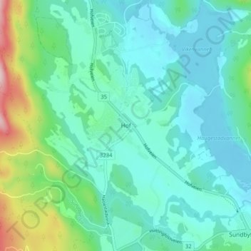
Name: Hof topographic map, elevation, terrain.

Location: Hof, Holmestrand, Vestfold og Telemark, 3090, Norway (59.51032 10.06832 59.55032 10.10832)

Average elevation: 97 m

Minimum elevation: 36 m

Maximum elevation: 338 m

Other topographic maps

Click on a map to view its topography, its elevation and its terrain.

Midt-Telemark

Norway > Vestfold og Telemark

Average elevation: 360 m

Fyresdal

Norway > Vestfold og Telemark

Average elevation: 693 m

Bordalsvatn

Norway > Vestfold og Telemark

Average elevation: 1,017 m

Kviteseid

Norway > Vestfold og Telemark

Average elevation: 594 m

Nissedal

Norway > Vestfold og Telemark

Average elevation: 500 m

Gear up for your next adventure:

Camping Coffee Maker - Brew fresh coffee anywhere on the topographic map
🥾Mountain Hiking Boots - High-traction boots for rocky terrain
🧰Multitool Knife - Compact and versatile tool for outdoor use
🥾Mountain Hiking Shoes - Shoes with superior grip for mountainous terrain
🧦Thermal Socks - Warm socks for winter hiking or camping

As an Amazon Associate, this site earns from qualifying purchases at no extra cost to you.