Geolocate

Midt-Telemark topographic map

Click on the map to display elevation.

About this map

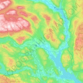
Name: Midt-Telemark topographic map, elevation, terrain.

Location: Midt-Telemark, Vestfold og Telemark, Norway (59.32214 8.81974 59.53590 9.47174)

Average elevation: 360 m

Minimum elevation: 10 m

Maximum elevation: 1,277 m

Other topographic maps

Click on a map to view its topography, its elevation and its terrain.

Larvik

Norway > Vestfold og Telemark

Average elevation: 45 m

Øvre Birtedalen

Norway > Vestfold og Telemark

Average elevation: 655 m

Kirkebygda

Norway > Vestfold og Telemark

Average elevation: 13 m

Torsberg

Norway > Vestfold og Telemark > Skien

Average elevation: 51 m

Finnmark

Norway > Vestfold og Telemark

Average elevation: 38 m

Treungen

Norway > Vestfold og Telemark

Average elevation: 357 m

Sauland

Norway > Vestfold og Telemark

Average elevation: 210 m

Valberg

Norway > Vestfold og Telemark

Average elevation: 57 m

Hof

Norway > Vestfold og Telemark

Average elevation: 97 m

Gear up for your next adventure:

🩹Compact First Aid Kit - Pre-packed essentials for common trail injuries
🧭GPS Outdoor Watch - Smart watch for navigation and fitness tracking in nature
🧊Portable Cooler - Keep food and drinks cold during outdoor adventures
🧤Thermal Hiking Gloves - Grip-enhanced gloves for cold-weather altitude trekking
🔥Emergency Fire Starter - Reliable ignition source for all weather conditions

As an Amazon Associate, this site earns from qualifying purchases at no extra cost to you.