
Elsa topographic map
Click on the map to display elevation.
About this map
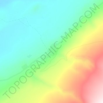
Name: Elsa topographic map, elevation, terrain.
Location: Elsa, Yukon, Canada (63.89172 -135.51024 63.93172 -135.47024)
Average elevation: 894 m
Minimum elevation: 666 m
Maximum elevation: 1,378 m
Yukon trails, hiking, mountain biking, running and outdoor activities
Other topographic maps
Click on a map to view its topography, its elevation and its terrain.
Whitehorse
Whitehorse has a subarctic climate (Köppen climate classification: Dfc) and lies in the rain shadow of the Coast Mountains, causing precipitation totals to be quite low year-round. Due to the city's location in the Whitehorse valley, the climate is milder than other comparable northern communities such as…
Average elevation: 1,007 m
Kusawa Lake
Kusawa Lake is a lake in the southern Yukon, Canada. Kusawa means "long narrow lake" in the Tlingit language. The Kusawa Lake is a lake in Canada's Yukon Territory. It is located at an altitude of 671 m (2,201 ft) and is 60 km (37 mi) southwest of Whitehorse near the British Columbia border. It meanders over a…
Average elevation: 1,282 m
Beaver Creek
Like most of Yukon, Beaver Creek has a subarctic climate (Dfc), and NRC Plant Hardiness Zone of 0a. It is situated at an elevation of approximately 650 m (2,130 ft). Beaver Creek experiences annual temperature average daily highs of 20 °C (68 °F) in July and average daily lows of −30 °C (−22 °F) in…
Average elevation: 669 m
Kluane National Park and Reserve
The Reserve includes the highest mountain in Canada, Mount Logan (5,959 metres or 19,551 feet) of the Saint Elias Mountains. Mountains and glaciers, including Donjek Glacier, dominate the park's landscape, covering 83% of its area. The rest of the land in the park is forest and tundra—east of the largest…
Average elevation: 1,536 m
Dawson City
The community is at an elevation of 320 m (1,050 ft) and the average rainfall in July is 49.0 mm (1.93 in) and the average snowfall in January is 27.6 cm (10.87 in). Dawson has an average total annual snowfall of 166.5 cm (65.55 in) and averages 70 frost free days per year. The town is built on a layer of…
Average elevation: 507 m
Beaver Creek
Canada > Yukon > Beaver Creek
Like most of Yukon, Beaver Creek has a subarctic climate (Dfc), and NRC Plant Hardiness Zone of 0a. It is situated at an elevation of approximately 650 m (2,130 ft). Beaver Creek experiences annual temperature average daily highs of 20 °C (68 °F) in July and average daily lows of −30 °C (−22 °F) in…
Average elevation: 662 m
Bennett Lake
Canada > Yukon > Stikine Region > Carcross
Bennett Lake is a lake in the Province of British Columbia and Yukon Territory in northwestern Canada, at an elevation of 656 m (2,152 ft). It is just north of the border with the United States state of Alaska, near the Alaskan port of Skagway. The lake has an estimated area of about 90.68 or 96.8 km2 (35.01…
Average elevation: 1,189 m
Pelly River
The Pelly rises in glaciers on the western slopes of the Selwyn Mountains above 1,400 m (4,600 ft) in elevation, close to the Yukon-Northwest Territories boundary. It flows south and west through a wide valley, receiving many small tributaries from the east. It passes the Pelly Lakes, out of which flows the…
Average elevation: 809 m
Whitehorse
Whitehorse has a subarctic climate (Köppen climate classification: Dfc, Trewartha Eclc) and lies in the rain shadow of the Coast Mountains, causing precipitation totals to be quite low year-round. Due to the city's location in the Whitehorse valley, the climate is milder than other comparable northern…
Average elevation: 1,007 m
Whitehorse
Whitehorse has a subarctic climate (Köppen climate classification: Dfc) and lies in the rain shadow of the Coast Mountains, causing precipitation totals to be quite low year-round. Due to the city's location in the Whitehorse valley, the climate is milder than other comparable northern communities such as…
Average elevation: 1,007 m
Whitehorse
Whitehorse has a subarctic climate (Köppen climate classification: Dfc, Trewartha Eclc) and lies in the rain shadow of the Coast Mountains, causing precipitation totals to be quite low year-round. Due to the city's location in the Whitehorse valley, the climate is milder than other comparable northern…
Average elevation: 1,007 m
Whitehorse
Whitehorse has a subarctic climate (Köppen climate classification: Dfc, Trewartha Eclc) and lies in the rain shadow of the Coast Mountains, causing precipitation totals to be quite low year-round. Due to the city's location in the Whitehorse valley, the climate is milder than other comparable northern…
Average elevation: 1,007 m
Dawson City
The community is at an elevation of 320 m (1,050 ft) and the average rainfall in July is 49.0 mm (1.93 in) and the average snowfall in January is 27.6 cm (10.87 in). Dawson has an average total annual snowfall of 166.5 cm (65.55 in) and averages 70 frost free days per year. The town is built on a layer of…
Average elevation: 507 m