Geolocate

Aishihik topographic map

Click on the map to display elevation.

About this map

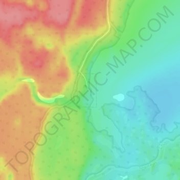
Name: Aishihik topographic map, elevation, terrain.

Location: Aishihik, Yukon, Canada (61.59599 -137.51106 61.60111 -137.50497)

Average elevation: 938 m

Minimum elevation: 901 m

Maximum elevation: 984 m

Yukon trails, hiking, mountain biking, running and outdoor activities

Gear up for your next adventure:

🌡️Emergency Mylar Blankets - Compact thermal protection for unexpected nights outdoors
🧢Sun Hat - Wide-brim hat for sun protection
🎒Backpack Rain Cover - External shield to keep your entire pack dry
🗺️Topographic Maps - Detailed maps to explore trails, mountains, and wilderness areas
🛶Canoe Life Vest - Safety vest for water sports

As an Amazon Associate, this site earns from qualifying purchases at no extra cost to you.