Geolocate

Sarnano topographic map

Click on the map to display elevation.

About this map

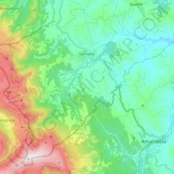
Name: Sarnano topographic map, elevation, terrain.

Location: Sarnano, Macerata, Marche, 62028, Italy (42.96450 13.22051 43.06413 13.37090)

Average elevation: 752 m

Minimum elevation: 316 m

Maximum elevation: 1,913 m

Other topographic maps

Click on a map to view its topography, its elevation and its terrain.

Vecciola di Sopra

Italy > Marche > Macerata > Sarnano

Average elevation: 529 m

San Martino

Italy > Marche > Macerata > Sant'Angelo in Pontano

Average elevation: 274 m

Anselmi

Italy > Marche > Macerata > Monte San Martino

Average elevation: 405 m

Aurora

Italy > Marche > Macerata > Civitanova Marche

Average elevation: 24 m

Vestignano

Italy > Marche > Macerata > Caldarola

Average elevation: 630 m

Gear up for your next adventure:

🧼Travel Hand Sanitizer - Keep hands clean when water is scarce
❄️Traction Ice Cleats - Slip-on spikes for icy trails and winter hiking
🛰️Satellite Messenger - Emergency communication for areas with no cell service
💧Reusable Water Bottle - Durable water bottles for hydration on trails
🧥Fleece Jacket - Warm and lightweight jacket for layering

As an Amazon Associate, this site earns from qualifying purchases at no extra cost to you.