Geolocate

Anselmi topographic map

Click on the map to display elevation.

About this map

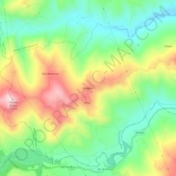
Name: Anselmi topographic map, elevation, terrain.

Location: Anselmi, Monte San Martino, Macerata, Marche, Italy (43.00614 13.38828 43.04614 13.42828)

Average elevation: 405 m

Minimum elevation: 253 m

Maximum elevation: 634 m

Gear up for your next adventure:

🛶Kayak Accessories - Essential gear for safe and fun kayaking adventures
🎒Fully Waterproof Backpack - Total protection for photography gear and electronics
🛏️Sleeping Bag - Warm and compact sleeping bags for outdoor camping
Camping Groundsheet - Protect your tent from moisture and dirt
🧢Hiking Sun Hat - Wide-brimmed protection for exposed mountain ridges

As an Amazon Associate, this site earns from qualifying purchases at no extra cost to you.