Geolocate

Aurora topographic map

Click on the map to display elevation.

About this map

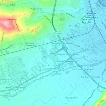
Name: Aurora topographic map, elevation, terrain.

Location: Aurora, Civitanova Marche, Macerata, Marche, 62012, Italy (43.27328 13.68555 43.31328 13.72555)

Average elevation: 24 m

Minimum elevation: -1 m

Maximum elevation: 147 m

Gear up for your next adventure:

🔭Compact Binoculars - Lightweight optics for scouting trails and wildlife
🧰Multitool Knife - Compact and versatile tool for outdoor use
📷Outdoor Action Camera - Capture high-elevation views and rugged adventures
🛰️Satellite Messenger - Emergency communication for areas with no cell service
🐕Hiking Dog Pack - Let your canine companion carry their own water and food

As an Amazon Associate, this site earns from qualifying purchases at no extra cost to you.