Geolocate

Bergamo topographic map

Click on the map to display elevation.

About this map

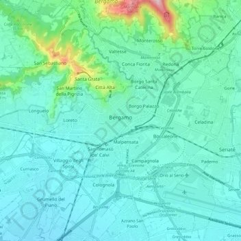
Name: Bergamo topographic map, elevation, terrain.

Location: Bergamo, Lombardy, 24121-24129, Italy (45.65542 9.61936 45.73140 9.71371)

Average elevation: 269 m

Minimum elevation: 206 m

Maximum elevation: 615 m

Other topographic maps

Click on a map to view its topography, its elevation and its terrain.

Xino

Italy > Lombardy > Bergamo > Fonteno

Average elevation: 512 m

Tezzi Alti

Italy > Lombardy > Bergamo > Gandellino

Average elevation: 1,225 m

Bani

Italy > Lombardy > Bergamo > Ardesio

Average elevation: 1,064 m

Sogno

Italy > Lombardy > Bergamo > Torre de' Busi > San Marco

Average elevation: 842 m

Piangaiano

Italy > Lombardy > Bergamo

Average elevation: 557 m

Clanezzo

Italy > Lombardy > Bergamo > Ubiale Clanezzo

Average elevation: 401 m

Bani

Italy > Lombardy > Bergamo > Ardesio

Average elevation: 1,064 m

Borghetto

Italy > Lombardy > Bergamo > Burligo

Average elevation: 522 m

Tiglio

Italy > Lombardy > Bergamo > Zogno

Average elevation: 621 m

Lizzola

Italy > Lombardy > Bergamo

Average elevation: 1,517 m

Bondione

Italy > Lombardy > Bergamo > Lizzola

Average elevation: 1,457 m

Gear up for your next adventure:

💧Hydration Bladder - Hands-free hydration solution for long treks
🦶Hiking Shoe Insoles - Added support for high arches and long days on feet
🧦Hiking Liner Socks - Thin base layer to prevent friction and blisters
🔦LED Headlamp - Hands-free lighting for early morning starts or late finishes
🌡️Emergency Mylar Blankets - Compact thermal protection for unexpected nights outdoors

As an Amazon Associate, this site earns from qualifying purchases at no extra cost to you.