
Make a donation
Gear up for your next adventure:
As an Amazon Associate, this site earns from qualifying purchases at no extra cost to you.
Burleigh Falls topographic map
Click on the map to display elevation.
Make a donation
Gear up for your next adventure:
As an Amazon Associate, this site earns from qualifying purchases at no extra cost to you.
About this map
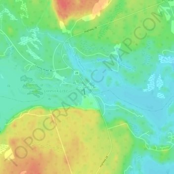
Name: Burleigh Falls topographic map, elevation, terrain.
Average elevation: 253 m
Minimum elevation: 231 m
Maximum elevation: 288 m
Peterborough County trails, hiking, mountain biking, running and outdoor activities
Make a donation
Gear up for your next adventure:
As an Amazon Associate, this site earns from qualifying purchases at no extra cost to you.
Other topographic maps
Click on a map to view its topography, its elevation and its terrain.
Kawartha Highlands Provincial Park
Canada > Ontario > Peterborough County > North Kawartha
Average elevation: 306 m
Trent-Severn Waterway
Canada > Ontario > Peterborough County > North Kawartha > Burleigh Falls
Average elevation: 249 m
Make a donation
Gear up for your next adventure:
As an Amazon Associate, this site earns from qualifying purchases at no extra cost to you.
Stony Lake
Canada > Ontario > Peterborough County > North Kawartha > Burleigh Falls
Average elevation: 255 m
Make a donation
Gear up for your next adventure:
As an Amazon Associate, this site earns from qualifying purchases at no extra cost to you.