
Make a donation
Gear up for your next adventure:
As an Amazon Associate, this site earns from qualifying purchases at no extra cost to you.
Himmelstadt topographic map
Click on the map to display elevation.
Make a donation
Gear up for your next adventure:
As an Amazon Associate, this site earns from qualifying purchases at no extra cost to you.
Himmelstadt
Der Tiefe Brunnen von 1730 diente der Wasserversorgung der höher gelegenen Ummenstaller Höfe. Diese waren bis 1823 im Besitz des Klosters und blieben bis 1905 bewohnt. Im Jahr 2015 wurde der Tiefe Brunnen auf Initiative des Arbeitskreises Tourismus restauriert, liegt jedoch heute trocken.
Make a donation
Gear up for your next adventure:
As an Amazon Associate, this site earns from qualifying purchases at no extra cost to you.
About this map
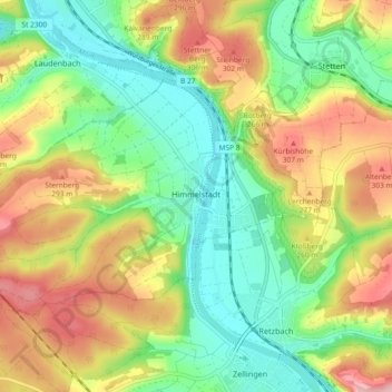
Name: Himmelstadt topographic map, elevation, terrain.
Average elevation: 232 m
Minimum elevation: 154 m
Maximum elevation: 343 m
Make a donation
Gear up for your next adventure:
As an Amazon Associate, this site earns from qualifying purchases at no extra cost to you.
Other topographic maps
Click on a map to view its topography, its elevation and its terrain.
Make a donation
Gear up for your next adventure:
As an Amazon Associate, this site earns from qualifying purchases at no extra cost to you.
Neustadt a. Main
Deutschland > Bayern > Landkreis Main-Spessart > Neustadt a.Main
Average elevation: 299 m
Marktheidenfeld
Deutschland > Bayern > Landkreis Main-Spessart > Marktheidenfeld > Marktheidenfeld
Average elevation: 236 m
Gut Ebenroth
Deutschland > Bayern > Landkreis Main-Spessart > Arnstein > Reuchelheim
Average elevation: 297 m
Make a donation
Gear up for your next adventure:
As an Amazon Associate, this site earns from qualifying purchases at no extra cost to you.
Brückenfundamentloch Reichsautobahn Strecke 46, Fulda-Würzburg
Deutschland > Bayern > Landkreis Main-Spessart > Gemünden am Main > Seifriedsburg
Average elevation: 307 m
Make a donation
Gear up for your next adventure:
As an Amazon Associate, this site earns from qualifying purchases at no extra cost to you.
Eichenfürst
Deutschland > Bayern > Landkreis Main-Spessart > Marktheidenfeld > Altfeld
Average elevation: 253 m
Hasberg
Deutschland > Bayern > Landkreis Main-Spessart > Ruppertshüttener Forst
Average elevation: 417 m
Make a donation
Gear up for your next adventure:
As an Amazon Associate, this site earns from qualifying purchases at no extra cost to you.
Make a donation
Gear up for your next adventure:
As an Amazon Associate, this site earns from qualifying purchases at no extra cost to you.
Make a donation
Gear up for your next adventure:
As an Amazon Associate, this site earns from qualifying purchases at no extra cost to you.
Bayerische Schanz (507,9)
Deutschland > Bayern > Landkreis Main-Spessart > Lohr am Main
Average elevation: 491 m
Rengersbrunn
Deutschland > Bayern > Landkreis Main-Spessart > Fellen > Rengersbrunn
Average elevation: 437 m
Make a donation
Gear up for your next adventure:
As an Amazon Associate, this site earns from qualifying purchases at no extra cost to you.
Arnstein
Deutschland > Bayern > Landkreis Main-Spessart > Arnstein > Arnstein
Average elevation: 279 m
Adelsberg
Deutschland > Bayern > Landkreis Main-Spessart > Gemünden am Main > Adelsberg
Average elevation: 246 m
Make a donation
Gear up for your next adventure:
As an Amazon Associate, this site earns from qualifying purchases at no extra cost to you.
Seifriedsburg
Deutschland > Bayern > Landkreis Main-Spessart > Gemünden am Main
Average elevation: 289 m
Langenprozelten
Deutschland > Bayern > Landkreis Main-Spessart > Gemünden am Main
Average elevation: 246 m
Make a donation
Gear up for your next adventure:
As an Amazon Associate, this site earns from qualifying purchases at no extra cost to you.