
Langenprozelten topographic map
Click on the map to display elevation.
About this map
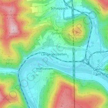
Name: Langenprozelten topographic map, elevation, terrain.
Average elevation: 246 m
Minimum elevation: 147 m
Maximum elevation: 457 m
Other topographic maps
Click on a map to view its topography, its elevation and its terrain.
Seifriedsburg
Deutschland > Bayern > Landkreis Main-Spessart > Gemünden am Main
Average elevation: 287 m
Brückenfundamentloch Reichsautobahn Strecke 46, Fulda-Würzburg
Deutschland > Bayern > Landkreis Main-Spessart > Gemünden am Main > Seifriedsburg
Average elevation: 307 m
97737
Deutschland > Bayern > Landkreis Main-Spessart > Gemünden am Main > Hofstetten
Average elevation: 242 m
Langenprozelten
Deutschland > Bayern > Landkreis Main-Spessart > Gemünden am Main
Average elevation: 323 m