
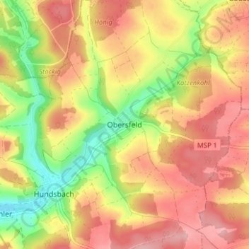
Obersfeld topographic map
Click on the map to display elevation.
About this map
Name: Obersfeld topographic map, elevation, terrain.
Average elevation: 271 m
Minimum elevation: 195 m
Maximum elevation: 328 m
Other topographic maps
Click on a map to view its topography, its elevation and its terrain.
Steinmark
Deutschland > Bayern > Landkreis Main-Spessart > Kredenbach
Esselbach mit Faun, Karlshöhe, Schleifthor, Wagenmühle (alte) und Wagenmühle (neue) | Kredenbach | Steinmark mit Heinrichsmühle und Kieseckersmühle
Average elevation: 350 m
Partenstein
Deutschland > Bayern > Landkreis Main-Spessart
Partenstein liegt in der Region Main Spessart mitten im Spessart am linken Ufer der Lohr, etwa sieben Kilometer nordwestlich der Stadt Lohr am Main. Der topographisch höchste Punkt des Gemeindegebiets befindet sich mit 502 m ü. NHN am Gaulskopf, nordöstlich von Partenstein, der niedrigste liegt an der Lohr…
Average elevation: 330 m
Fürstlich Löwenstein'scher Park
Deutschland > Bayern > Landkreis Main-Spessart
Der Fürstlich Löwensteinsche Park ist das flächenmäßig größte gemeindefreie Gebiet im Landkreis und das aktuell zwölftgrößte in Bayern. Er liegt zwischen der Gemeinde Bischbrunn und der Stadt Rothenfels. Die höchste Erhebung ist die Hintere Bauhöhe mit 533 m ü. NN. Das Tal der Hafenlohr begrenzt…
Average elevation: 394 m
Gemünden am Main
Deutschland > Bayern > Landkreis Main-Spessart
In der Stadt mündet die Sinn in die Fränkische Saale und diese dann in den Main. Aus diesem Grund wird Gemünden am Main auch als „Drei-Flüsse-Stadt“ oder „fränkische Dreiflüssestadt“ bezeichnet. Der Main ändert in Gemünden seine Richtung von Nordwest auf West, um vom Maindreieck, das bei…
Average elevation: 281 m
Lohr am Main
Deutschland > Bayern > Landkreis Main-Spessart
Lohr liegt am Ostabhang des Spessarts an einer Flussbiegung des Mains, der hier nach Süden schwenkt. Damit beginnt das Mainviereck (Südteil des Spessarts). In Lohr münden die Lohr und der Rechtenbach in den Main. Der topographisch höchste Punkt des Stadtgebietes befindet sich mit 542 m ü. NHN am Gipfel…
Average elevation: 336 m
Marktheidenfeld
Deutschland > Bayern > Landkreis Main-Spessart
Die Kleinstadt liegt am Mainviereck an der Ostseite des Spessarts, geologisch an der Nahtstelle des Spessart-Rotsandsteingebiets zum Muschelkalkgebiet der Fränkischen Platte, die zwischen dem Mainviereck und dem Maindreieck auch als Marktheidenfelder Platte bezeichnet wird. Der topographisch höchste Punkt…
Average elevation: 260 m
Himmelstadt
Deutschland > Bayern > Landkreis Main-Spessart
Der Tiefe Brunnen von 1730 diente der Wasserversorgung der höher gelegenen Ummenstaller Höfe. Diese waren bis 1823 im Besitz des Klosters und blieben bis 1905 bewohnt. Im Jahr 2015 wurde der Tiefe Brunnen auf Initiative des Arbeitskreises Tourismus restauriert, liegt jedoch heute trocken.
Average elevation: 232 m
Schollbrunn
Deutschland > Bayern > Landkreis Main-Spessart
Die Gemeinde liegt in der Region Würzburg. Der topographisch höchste Punkt der Gemeindegemarkung befindet sich mit 465 m ü. NHN an der St 2316 nordwestlich von Schollbrunn, der niedrigste liegt am Kropfbach auf 174 m ü. NHN.
Average elevation: 350 m
Frammersbach
Deutschland > Bayern > Landkreis Main-Spessart
Der staatlich anerkannte Erholungsort liegt zwischen Würzburg und Aschaffenburg mitten im Naturpark Spessart. Der Hauptort liegt am Zulauf des Laubersbachs zur Lohr; Habichsthal in geographisch getrennter kleiner Gemarkung etwa fünf Kilometer westlich davon im kurzen Mühlbach-Seitental des erst unterhalb…
Average elevation: 363 m
Esselbach
Deutschland > Bayern > Landkreis Main-Spessart
Der topographisch höchste Punkt des zusammenhängenden Hauptteils der Gemeindegemarkung nahe an deren Nordspitze auf dem Steinmarker Berg (Lage)49.888599.49815 erreicht 437 m ü. NHN, der der gesamten Gemeinde an der Gemeindeexklave Karlshöhe(Lage)49.895339.51611 450 m ü. NHN, der niedrigste liegt am…
Average elevation: 341 m
Seifriedsburg
Deutschland > Bayern > Landkreis Main-Spessart > Gemünden am Main
Average elevation: 287 m
Burgsinn
Deutschland > Bayern > Landkreis Main-Spessart
Die Gemeinde liegt in der Region Main-Spessart (Nachbarlandkreis von Würzburg). Der topographisch höchste Punkt der Gemeindegemarkung befindet sich mit 509 m ü. NHN (Lage)50.103969.55615 an der Lohrer Höhe, der niedrigste liegt an der Sinn auf 174 m ü. NHN (Lage)50.123169.65844.
Average elevation: 323 m
Bischbrunn
Deutschland > Bayern > Landkreis Main-Spessart
Im Ort entspringt der Esselbach, der über den Wachenbach der Hafenlohr zufließt. Der topographisch höchste Punkt der Gemeinde befindet sich mit 586 m ü. NHN (Lage)49.90619.43005 auf dem Gipfel des Geiersberges, der höchsten Erhebung des Spessarts. Der niedrigste liegt am Haslochbach, in der Nähe der…
Average elevation: 395 m
Thüngen
Deutschland > Bayern > Landkreis Main-Spessart
Thüngen wird durchquert von der B 26. Auf Höhe des ehemaligen Gasthofes Schwarzer Adler trifft die Staatsstraße 2437 mit Anschluss an die B 27 Richtung Würzburg auf die B 26. Die elektrifizierte Werntalbahn wird fast ausschließlich von Güterverkehrszügen befahren. Die sommerlichen Fahrradzüge – die…
Average elevation: 264 m
Brückenfundamentloch Reichsautobahn Strecke 46, Fulda-Würzburg
Deutschland > Bayern > Landkreis Main-Spessart > Gemünden am Main > Seifriedsburg
Average elevation: 307 m
Hasloch
Deutschland > Bayern > Landkreis Main-Spessart
Die Gemeinde liegt im Südwesten des bayerischen Landkreises Main-Spessart im Maintal am Rande des Spessarts gegenüber von Bestenheid, einem Stadtteil der baden-württembergischen Stadt Wertheim. Der topographisch höchste Punkt der Gemeinde befindet sich mit 399 m ü. NHN (Lage)49.810949.47117 am Gipfel der…
Average elevation: 255 m
Rothenfels
Deutschland > Bayern > Landkreis Main-Spessart
Rothenfels liegt rechts des Mains zwischen Lohr am Main und Marktheidenfeld. Eingezwängt zwischen dem Fluss und einem Steilhang besteht die Stadt aus wenig mehr als einer Hauptstraße. Der topographisch höchste Punkt der Stadtgemarkung befindet sich mit 508 m ü. NHN am Dreßlingkopf, südlich von Aurora,…
Average elevation: 270 m
97828
Deutschland > Bayern > Landkreis Main-Spessart > Marktheidenfeld > Glasofen
Average elevation: 280 m
Hafenlohr
Deutschland > Bayern > Landkreis Main-Spessart
Der Ort Hafenlohr liegt in der Region Würzburg, etwa 3 km nördlich von Marktheidenfeld. Der topographisch höchste Punkt der Gemeinde befindet sich mit 319 m ü. NN (Lage)49.902949.55558 nördlich vom Forsthaus Fürstenbrücke, der niedrigste liegt im Main auf 142 m ü. NN (Lage)49.850819.59698.
Average elevation: 276 m
97737
Deutschland > Bayern > Landkreis Main-Spessart > Gemünden am Main > Hofstetten
Average elevation: 242 m
Wiesthal
Deutschland > Bayern > Landkreis Main-Spessart
Wiesthal liegt in der Region Main-Spessart, im Tal des Aubachs im Hochspessart. Der topographisch höchste Punkt der Gemeinde befindet sich mit 419 m ü. NHN (Lage)50.0359.4054 an der Baßhöhe, westlich von Wiesthal, der niedrigste liegt am Aubach auf 197 m ü. NHN (Lage)50.036619.48846.
Average elevation: 339 m
Langenprozelten
Deutschland > Bayern > Landkreis Main-Spessart > Gemünden am Main
Average elevation: 323 m
Rechtenbach
Deutschland > Bayern > Landkreis Main-Spessart
Rechtenbach liegt in der Region Würzburg im Spessart. Der topographisch höchste Punkt der Gemeinde befindet sich mit 536,6 m ü. NHN (Lage)49.992799.47913 an der Weickertshöhe, der niedrigste liegt an der B 26 kurz vor Lohr auf 203 m ü. NHN (Lage)49.991929.55424.
Average elevation: 444 m
Forst Lohrerstraße
Deutschland > Bayern > Landkreis Main-Spessart
Das Gebiet liegt südöstlich der Gemeinde Neuhütten mit dem namensgebenden Weiler Lohrerstraße. Die höchste Erhebung ist die Weickertshöhe mit 546 m ü. NN.
Average elevation: 426 m
Kreuzwertheim
Deutschland > Bayern > Landkreis Main-Spessart
Der Markt liegt südwestlich der Bundesautobahn 3 am Rande des Spessarts und gegenüber der baden-württembergischen Stadt Wertheim. Im Uferbereich des Mains gibt es Feucht- und Trockenwiesen. Auf den südlichen Talhängen befinden sich Weinberge oder Streuobstwiesen auf ehemaligen Weinbauterrassen, ansonsten…
Average elevation: 247 m
Altfeld
Deutschland > Bayern > Landkreis Main-Spessart > Marktheidenfeld
Der topographisch höchste Punkt der Gemarkung Altfeld befindet sich auf 371 m ü. NHN (Lage)49.835839.52862 am Birkenschlag, der niedrigste liegt etwa 350 Meter westsüdwestlich der Mündung des Klingelsbachgrabens auf 214 m ü. NHN (Lage)49.810639.58505.
Average elevation: 274 m
Forst Aura
Deutschland > Bayern > Landkreis Main-Spessart
Die Gemeinden Obersinn und Mittelsinn teilen den Forst Aura in zwei Bereiche. Der westliche liegt rechts der Sinn, nördlich der namensgebenden Gemeinde Aura im Sinngrund. Der östliche Teil befindet sich links der Sinn. Die höchste Erhebung ist die Bichlerhöhe mit 507 m ü. NN.
Average elevation: 360 m
Partensteiner Forst
Deutschland > Bayern > Landkreis Main-Spessart
Der Forst liegt südwestlich der namensgebenden Gemeinde Partenstein. Die Gemeinde Wiesthal teilt ihn in zwei getrennte Bereiche. Die höchste Erhebung ist die Weickertshöhe mit 546 m ü. NN.
Average elevation: 346 m
Hirschgrund
Deutschland > Bayern > Landkreis Main-Spessart > Partensteiner Forst
Average elevation: 403 m
Rieneck
Deutschland > Bayern > Landkreis Main-Spessart
Der Ort liegt in der Region Würzburg zwischen den südlichen Ausläufern der Rhön und der Ostseite des Spessarts am Unterlauf der Sinn. Der topographisch höchste Punkt der Stadtgemarkung befindet sich im Spessart mit 448 m ü. NHN (Lage)50.089299.58146, in der Nähe des ehemaligen Klosters Einsiedel, der…
Average elevation: 313 m
Fellen
Deutschland > Bayern > Landkreis Main-Spessart
Die Gemeinde liegt in der Region Würzburg an der Fella, knapp drei Kilometer östlich der hessisch-bayerischen Grenze. Der topographisch höchste Punkt der Gemeinde befindet sich mit 552 m ü. NHN (Lage)50.107599.5183 an der Hermannskoppe, der niedrigste liegt an der Aura auf 205 m ü. NHN (Lage)50.155649.61261.
Average elevation: 357 m
Neuhütten
Deutschland > Bayern > Landkreis Main-Spessart
Neuhütten liegt in der Region Würzburg im bayerischen Spessart. Der topographisch höchste Punkt der Gemeinde befindet sich mit 472 m ü. NHN (Lage)49.979449.45938 am Osthang des Hengstkopfes, in der Nähe des Bischbornerhofes, der niedrigste liegt am Lohrbach auf 232 m ü. NHN (Lage)50.016369.43143.
Average elevation: 376 m
Obersinn
Deutschland > Bayern > Landkreis Main-Spessart
Obersinn liegt in der Region Würzburg und wird durch den namensgebenden Fluss Sinn in eine Spessart- und in eine Rhönseite geteilt. Die Nachbarorte heißen: Mittelsinn und Jossa, sowie Zeitlofs-Roßbach und Aura im Sinngrund. Außerdem gibt es den Gemeindeteil Emmerichsthal. In der Nähe des Ortes liegt die…
Average elevation: 351 m
Roden
Deutschland > Bayern > Landkreis Main-Spessart
Kleine Gewerbebetriebe bieten nur eine geringe Zahl an Arbeitsplätzen vor Ort. Der überwiegende Teil der Bevölkerung pendelt nach Lohr, Marktheidenfeld oder Würzburg zur Arbeit. Die amtliche Statistik von 2017 weist 90 sozialversicherungspflichtige Arbeitsplätze in der Gemeinde aus, während von der…
Average elevation: 287 m
Wolfsrain
Deutschland > Bayern > Landkreis Main-Spessart > Frammersbacher Forst
Average elevation: 388 m
Sendelbach
Deutschland > Bayern > Landkreis Main-Spessart > Lohr am Main > Sendelbach
Average elevation: 233 m
Obersinn
Deutschland > Bayern > Landkreis Main-Spessart
Obersinn liegt in der Region Würzburg und wird durch den namensgebenden Fluss Sinn in eine Spessart- und in eine Rhönseite geteilt. Die Nachbarorte heißen: Mittelsinn und Jossa, sowie Zeitlofs-Roßbach und Aura im Sinngrund. Außerdem gibt es den Gemeindeteil Emmerichsthal. In der Nähe des Ortes liegt die…
Average elevation: 352 m
Triefenstein
Deutschland > Bayern > Landkreis Main-Spessart
Triefenstein liegt am südlichen Ende des Landkreises Main-Spessart im Mainviereck. Der Main teilt den Markt. Der topographisch höchste Punkt der Gemeinde befindet sich auf 303 m ü. NHN (Lage)49.805159.65265 am Husarenberg an der B 8 südlich von Tiefenthal, der niedrigste liegt im Main auf 138 m ü. NHN…
Average elevation: 225 m
Altfeld
Deutschland > Bayern > Landkreis Main-Spessart > Marktheidenfeld
Der topographisch höchste Punkt der Gemarkung Altfeld befindet sich auf 371 m ü. NHN (Lage)49.835839.52862 am Birkenschlag, der niedrigste liegt etwa 350 Meter westsüdwestlich der Mündung des Klingelsbachgrabens auf 214 m ü. NHN (Lage)49.810639.58505.
Average elevation: 274 m
Marktheidenfeld
Deutschland > Bayern > Landkreis Main-Spessart
Die Kleinstadt liegt am Mainviereck an der Ostseite des Spessarts, geologisch an der Nahtstelle des Spessart-Rotsandsteingebiets zum Muschelkalkgebiet der Fränkischen Platte, die zwischen dem Mainviereck und dem Maindreieck auch als Marktheidenfelder Platte bezeichnet wird. Der topographisch höchste Punkt…
Average elevation: 263 m