Geolocate

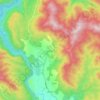
Mesopotamia topographic map

Click on the map to display elevation.

About this map
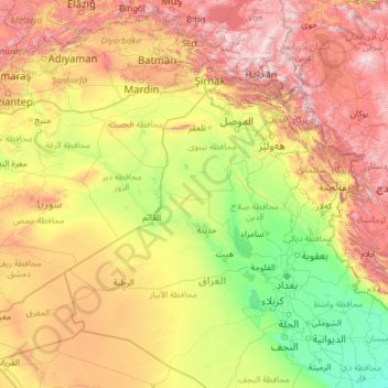
Name: Mesopotamia topographic map, elevation, terrain.

Location: Mesopotamia, Iraq (30.91048 37.83444 38.89591 47.45340)

Average elevation: 724 m

Minimum elevation: 1 m

Maximum elevation: 3,640 m

Other topographic maps

Click on a map to view its topography, its elevation and its terrain.

Mosul

Iraq > Nineveh Governorate

Average elevation: 282 m

Erbil

Iraq > Erbil Governorate > Erbil District

Average elevation: 462 m

Duhaymi Jasim

Iraq > Basra Governorate

Average elevation: 2 m

حي صنعاء

Iraq > Basra Governorate

Average elevation: 5 m

At Tannumah

Iraq > Basra Governorate

Average elevation: 3 m

Duhok

Iraq > Duhok Governorate > Duhok District

Average elevation: 681 m

Kirkuk

Iraq > Kirkuk Governorate

Average elevation: 383 m

Mawlawi

Iraq > Erbil Governorate > Erbil District > Erbil

Average elevation: 418 m

Bekhal

Iraq > Erbil Governorate > Rawanduz District

Average elevation: 830 m

Al-Faw

Iraq > Basra Governorate > Al-Faw District > Kut al Hajj Shayd

Another view suggests that the name is derived from the city’s position at the mouth (fāh) of the Shatt al-Arab, which evolved linguistically into Faw. Some sources, however, argue that the original word was al-Faʾu (الفأو), meaning “open land visible to the eye” or “land enclosed between two elevations”.

Average elevation: 1 m

Hayy domez

Iraq > Nineveh Governorate > Mosul District > Mosul

Average elevation: 225 m

Erbil

Iraq > Erbil Governorate > Erbil District

Average elevation: 462 m

Sinjar Mountains

Iraq > Nineveh Governorate > Sinjar District

The Sinjar Mountains (Kurdish: چیایێ شنگالێ, romanized: Çîyayê Şengalê, Arabic: جبل سنجار, romanized: Jabal Sinjār, Syriac: ܛܘܪܐ ܕܫܝܓܪ, romanized: Ṭura d'Shingar), is a 100-kilometre-long (62 mi) mountain range that runs east to west, rising above the surrounding alluvial…

Average elevation: 451 m

Shandukha

Iraq > Duhok Governorate > Duhok District

Average elevation: 604 m

Smaquk

Iraq > Nineveh Governorate > Akre District

Average elevation: 639 m

Tulail

Iraq > Kirkuk Governorate > Al-Hawija District

Average elevation: 179 m

Hit

Iraq > Al-Anbar Governorate > Hit District

Average elevation: 93 m

Pirzin

Iraq > Erbil Governorate > Erbil District

Average elevation: 506 m

Penjwen

Iraq > Sulaymaniyah Governorate > Penjwen District

Average elevation: 1,368 m

Gavarke

Iraq > Duhok Governorate > Duhok District

Average elevation: 539 m

Tall Zuaitit

Iraq > Baghdad Governorate

Average elevation: 39 m

Kani Kand

Iraq > Erbil Governorate > Koy Sinjaq District

Average elevation: 705 m

Basra

Iraq > Basra Governorate > Al-Basrah District

Average elevation: 4 m

Razyan

Iraq > Erbil Governorate > Mergasur District

Average elevation: 834 m

Tikrit

Iraq > Saladin Governorate

Average elevation: 111 m

Tanahi

Iraq > Duhok Governorate > Simele District

Average elevation: 518 m

Galala

Iraq > Erbil Governorate

Average elevation: 1,395 m

Nubi Tahrah

Iraq > Diyala Governorate

Average elevation: 91 m

Ooo

Iraq > Al-Anbar Governorate

Average elevation: 201 m

Safeen mountain

Iraq > Erbil Governorate > Pirmam District

Average elevation: 1,017 m

Tuz Khormato

Iraq > Saladin Governorate

Average elevation: 239 m

Qinan

Iraq > Al-Anbar Governorate

Average elevation: 72 m

Qinan

Iraq > Al-Anbar Governorate

Average elevation: 72 m

Basra

Iraq > Basra Governorate

Average elevation: 4 m

Ash Shawmalī

Iraq > Babil Governorate

Average elevation: 25 m

Samarra

Iraq > Saladin Governorate

Average elevation: 74 m

Bawageldy

Iraq > Sulaymaniyah Governorate

Average elevation: 787 m

Erbil

Iraq > Erbil Governorate > Erbil District

Average elevation: 462 m

Al Batha

Iraq > Dhi Qar Governorate

Average elevation: 8 m

Al Qadisiyah

Iraq > Al-Najaf Governorate

Average elevation: 29 m

Gorasher Lower

Iraq > Erbil Governorate > Pirmam District

Average elevation: 1,138 m

Kirkuk

Iraq > Kirkuk Governorate > Kirkuk District

Average elevation: 383 m

Al Qadisiyah

Iraq > Al-Najaf Governorate

Average elevation: 29 m

Karbala

Iraq > Karbala Governorate > Karbala District

Average elevation: 40 m

Al-Rabiah

Iraq > Basra Governorate > Al Hayaniyah

Average elevation: 4 m

deraluk

Iraq > Duhok Governorate

Average elevation: 903 m

Sulaymaniyah

Iraq > Sulaymaniyah Governorate

Average elevation: 977 m

Al Hillah

Iraq > Babil Governorate

Average elevation: 29 m

Karbala

Iraq > Karbala Governorate

Average elevation: 40 m

Chamiyala Lower

Iraq > Sulaymaniyah Governorate

Average elevation: 1,237 m

Mount Qandil

Iraq

Average elevation: 2,937 m

Az Zubayr

Iraq > Basra Governorate

Average elevation: 8 m

Duhok

Iraq > Duhok Governorate > Duhok District

Average elevation: 681 m

Khabat

Iraq > Erbil Governorate

Average elevation: 295 m

Babylon

Iraq > Babil Governorate > Qaryat Annan

A topographical survey at the site was conducted in 1974, followed in 1977 by a review of the stratigraphical position of the main monuments and reconsideration of ancient water levels, by the Turin Centre for Archaeological Research and Excavations in the Middle East and Asia, and the Iraqi-Italian Institute…

Average elevation: 32 m

Spindara

Iraq > Erbil Governorate

Average elevation: 1,142 m

Maree

Iraq > Kirkuk Governorate

Average elevation: 314 m

Karagal

Iraq > Sulaymaniyah Governorate

Average elevation: 1,363 m

Faidah

Iraq > Nineveh Governorate

Average elevation: 412 m

Kirkuk

Iraq > Kirkuk Governorate

Average elevation: 383 m

Sangasar

Iraq > Sulaymaniyah Governorate

Average elevation: 566 m

Halabja

Iraq > Halabja Governorate > Halabja District

Halabja is located in the Shahrizor plain, a fertile valley nestled in the foothills of the Zagros Mountains in the Kurdistan Region of Iraq. The city's elevation is around 700 meters above sea level. The surrounding area is characterized by mountainous terrain, with the Hawraman Mountain range to the east,…

Average elevation: 901 m

Karbala

Iraq > Karbala Governorate

Average elevation: 40 m

Mawat

Iraq > Sulaymaniyah Governorate

Average elevation: 1,135 m

Uruk

Iraq > Muthanna > As Samawah

Average elevation: 12 m

Kalar

Iraq > Sulaymaniyah Governorate

Average elevation: 289 m

Soran

Iraq > Erbil Governorate

Average elevation: 762 m

Sheladiza

Iraq

Average elevation: 659 m

Shekhan

Iraq > Erbil Governorate

Average elevation: 1,352 m

Basra

Iraq > Basra Governorate

Average elevation: 4 m

Fallujah

Iraq > Al-Anbar Governorate

Average elevation: 49 m

Al-Faw

Iraq > Basra Governorate

Another view suggests that the name is derived from the city’s position at the mouth (fāh) of the Shatt al-Arab, which evolved linguistically into Faw. Some sources, however, argue that the original word was al-Faʾu (الفأو), meaning “open land visible to the eye” or “land enclosed between two elevations”.

Average elevation: 1 m

Gear up for your next adventure:

🧦Crew Hiking Socks - Comfortable socks for long-distance hikes
⛺Camping Tent - Weather-resistant tents suitable for 2 to 6 people
🛶Canoe Life Vest - Safety vest for water sports
🧥Insulated Jacket - Keep warm in cold outdoor conditions
🔋Solar Power Bank - Keep your GPS and devices charged during long outdoor trips

As an Amazon Associate, this site earns from qualifying purchases at no extra cost to you.