
Welwyn Garden City topographic map
Interactive map
Click on the map to display elevation.
About this map
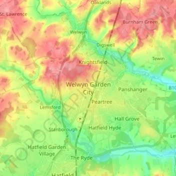
Name: Welwyn Garden City topographic map, elevation, terrain.
Average elevation: 89 m
Minimum elevation: 48 m
Maximum elevation: 134 m
Other topographic maps
Click on a map to view its topography, its elevation and its terrain.
Ayot St Peter
United Kingdom > England > Hertfordshire > Welwyn Hatfield > Welwyn Garden City
Ayot St Peter, Welwyn Garden City, Welwyn Hatfield, Hertfordshire, England, United Kingdom
Average elevation: 103 m
Gobions Pond
United Kingdom > England > Hertfordshire > Welwyn Hatfield > Brookmans Park > Swanley Bar
Gobions Pond, Swanley Bar, North Mymms, Brookmans Park, Welwyn Hatfield, Hertfordshire, England, United Kingdom
Average elevation: 106 m
Hatfield
United Kingdom > England > Hertfordshire > Welwyn Hatfield
Hatfield, Welwyn Hatfield, Hertfordshire, England, United Kingdom
Average elevation: 90 m
Oaklands
United Kingdom > England > Hertfordshire > Welwyn Hatfield
Oaklands, Welwyn Hatfield, Hertfordshire, England, AL6 0QN, United Kingdom
Average elevation: 105 m
Mardley Heath
United Kingdom > England > Hertfordshire > Welwyn Hatfield > Oaklands
Mardley Heath, Welwyn, Oaklands, Welwyn Hatfield, Hertfordshire, England, United Kingdom
Average elevation: 110 m
Welwyn
United Kingdom > England > Hertfordshire > Welwyn Hatfield
Welwyn, Digswell, Welwyn Hatfield, Hertfordshire, England, United Kingdom
Average elevation: 102 m
Ellenbrook Fields
United Kingdom > England > Hertfordshire > Welwyn Hatfield > Hatfield
Ellenbrook Fields, Hatfield Business Park, Hatfield, Welwyn Hatfield, Hertfordshire, East of England, England, United Kingdom
Average elevation: 80 m
Northaw
United Kingdom > England > Hertfordshire > Welwyn Hatfield
Northaw, Welwyn Hatfield, Hertfordshire, England, EN6 4NN, United Kingdom
Average elevation: 99 m
Great Wood Northaw Country Park
United Kingdom > England > Hertfordshire > Welwyn Hatfield > Hatfield
Great Wood Northaw Country Park, Northaw and Cuffley, Hatfield, Welwyn Hatfield, Hertfordshire, East of England, England, United Kingdom
Average elevation: 106 m
Digswell
United Kingdom > England > Hertfordshire > Welwyn Hatfield
Digswell, Welwyn Hatfield, Hertfordshire, England, AL6 0DX, United Kingdom
Average elevation: 95 m
North Mymms
United Kingdom > England > Hertfordshire > Welwyn Hatfield
North Mymms, Welwyn Hatfield, Hertfordshire, England, United Kingdom
Average elevation: 102 m