
Welwyn topographic map
Click on the map to display elevation.
About this map
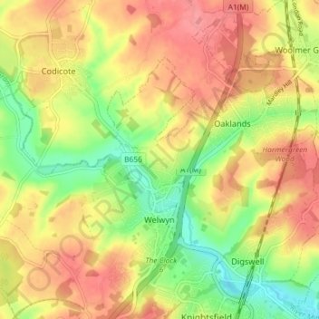
Name: Welwyn topographic map, elevation, terrain.
Average elevation: 102 m
Minimum elevation: 58 m
Maximum elevation: 135 m
Other topographic maps
Click on a map to view its topography, its elevation and its terrain.
Stanborough Park
United Kingdom > England > Hertfordshire > Welwyn Hatfield > Hatfield > Stanborough
Average elevation: 79 m
Ellenbrook Fields
United Kingdom > England > Hertfordshire > Welwyn Hatfield > Hatfield
Average elevation: 80 m
Mardley Heath
United Kingdom > England > Hertfordshire > Welwyn Hatfield > Oaklands
Average elevation: 110 m
Gobions Pond
United Kingdom > England > Hertfordshire > Welwyn Hatfield > Brookmans Park > Swanley Bar
Average elevation: 106 m
Mardleybury
United Kingdom > England > Hertfordshire > Welwyn Hatfield > Woolmer Green
Average elevation: 109 m
Great Wood Northaw Country Park
United Kingdom > England > Hertfordshire > Welwyn Hatfield > Hatfield
Average elevation: 106 m
Mill Green
United Kingdom > England > Hertfordshire > Welwyn Hatfield > Hatfield
Average elevation: 81 m