
Whitehouse topographic map
Click on the map to display elevation.
About this map
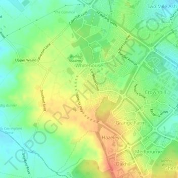
Name: Whitehouse topographic map, elevation, terrain.
Average elevation: 99 m
Minimum elevation: 78 m
Maximum elevation: 123 m
Other topographic maps
Click on a map to view its topography, its elevation and its terrain.
Willen Lake
United Kingdom > England > City of Milton Keynes > Milton Keynes > Monkston
Average elevation: 67 m
Milton Keynes
United Kingdom > England > City of Milton Keynes > Milton Keynes
Average elevation: 90 m
Walton Lake
United Kingdom > England > City of Milton Keynes > Milton Keynes > Monkston
Average elevation: 73 m
Whitehouse Park
United Kingdom > England > City of Milton Keynes > Milton Keynes > Wolverton
Average elevation: 99 m
Fenny Stratford
United Kingdom > England > City of Milton Keynes > Milton Keynes
Average elevation: 95 m