
Imereti topographic map
Interactive map
Click on the map to display elevation.
About this map
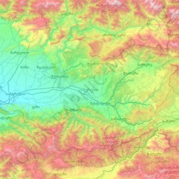
Name: Imereti topographic map, elevation, terrain.
Location: Imereti, Georgia (41.80902 42.21374 42.56590 43.67443)
Average elevation: 1,065 m
Minimum elevation: 7 m
Maximum elevation: 3,543 m
Other topographic maps
Click on a map to view its topography, its elevation and its terrain.
Khevi
Georgia > Imereti > Raion Kharagauli
Khevi, Raion Kharagauli, Imereti, Georgia
Average elevation: 641 m
Chiatura
Georgia > Imereti > Raion Chiatura > Chiatura
Chiatura, Raion Chiatura, Imereti, 5500, Georgia
Average elevation: 603 m
Tskaltubo
Georgia > Imereti > Tskaltubo Municipality > Tskaltubo
Tskaltubo, Tskaltubo Municipality, Imereti, 5400, Georgia
Average elevation: 135 m
Zestaponi
Georgia > Imereti > Zestaponi Municipality > Zestaponi
Zestaponi, Zestaponi Municipality, Imereti, Georgia
Average elevation: 209 m
Vani
Georgia > Imereti > Vani Municipality > Vani
Vani, Vani Municipality, Imereti, Georgia
Average elevation: 114 m