
Drybrook topographic map
Click on the map to display elevation.
About this map
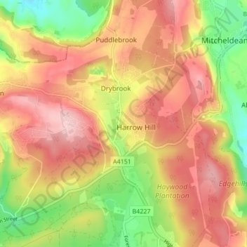
Name: Drybrook topographic map, elevation, terrain.
Average elevation: 210 m
Minimum elevation: 105 m
Maximum elevation: 291 m
Other topographic maps
Click on a map to view its topography, its elevation and its terrain.
Bream Meend
United Kingdom > England > Gloucestershire > Forest of Dean > Bream
Average elevation: 140 m
Joyford
United Kingdom > England > Gloucestershire > Forest of Dean > Berry Hill
Average elevation: 188 m
Highbury
United Kingdom > England > Gloucestershire > Forest of Dean > Lydney > Allaston
Average elevation: 65 m
Grange Village
United Kingdom > England > Gloucestershire > Forest of Dean > Littledean
Average elevation: 98 m
Saunders Green
United Kingdom > England > Gloucestershire > Forest of Dean > Whitecroft
Average elevation: 111 m
Bakers Hill
United Kingdom > England > Gloucestershire > Forest of Dean > Broadwell
Average elevation: 195 m
Lydney Hub
United Kingdom > England > Gloucestershire > Forest of Dean > Lydney > Allaston > Tutnalls
Average elevation: 42 m
Newent Woods
United Kingdom > England > Gloucestershire > Forest of Dean > May Hill
Average elevation: 157 m
The Pludds
United Kingdom > England > Gloucestershire > Forest of Dean > Ruardean
Average elevation: 170 m
Joys Green
United Kingdom > England > Gloucestershire > Forest of Dean > Upper Lydbrook
Average elevation: 142 m
Ruardean Hill
United Kingdom > England > Gloucestershire > Forest of Dean > Drybrook
Average elevation: 204 m
Plump Hill
United Kingdom > England > Gloucestershire > Forest of Dean > Abenhall > Plump Hill
Average elevation: 195 m
Crumpmeadow Inclosure
United Kingdom > England > Gloucestershire > Forest of Dean > Cinderford
Average elevation: 167 m
Lower Berry Hill
United Kingdom > England > Gloucestershire > Forest of Dean > Berry Hill
Average elevation: 193 m
Yorkley Wood
United Kingdom > England > Gloucestershire > Forest of Dean > Pillowell > Yorkley Bottom
Average elevation: 122 m
Fossil Beach
United Kingdom > England > Gloucestershire > Forest of Dean > Sedbury
Average elevation: 14 m
Hope Valley
United Kingdom > England > Gloucestershire > Forest of Dean > Lydney > Aylburton
Average elevation: 61 m
Brand Green
United Kingdom > England > Gloucestershire > Forest of Dean > Pauntley
Average elevation: 47 m
Lower Soudley
United Kingdom > England > Gloucestershire > Forest of Dean > Upper Soudley
Average elevation: 119 m
Poolway
United Kingdom > England > Gloucestershire > Forest of Dean > Coleford
Average elevation: 197 m
Speech House Lake
United Kingdom > England > Gloucestershire > Forest of Dean
Average elevation: 148 m
Green Bottom
United Kingdom > England > Gloucestershire > Forest of Dean > Popes Hill
Average elevation: 150 m
Broadoak
United Kingdom > England > Gloucestershire > Forest of Dean > Newnham on Severn
Average elevation: 30 m
The Scarr
United Kingdom > England > Gloucestershire > Forest of Dean > Newent
Average elevation: 55 m
Plump Hill
United Kingdom > England > Gloucestershire > Forest of Dean > Abenhall
Average elevation: 172 m
Lydney Harbour
United Kingdom > England > Gloucestershire > Forest of Dean > Lydney > Naas
Average elevation: 7 m
Ruardean Woodside
United Kingdom > England > Gloucestershire > Forest of Dean > Ruardean
Average elevation: 186 m
Land Grove
United Kingdom > England > Gloucestershire > Forest of Dean > Mitcheldean
Average elevation: 157 m
Glasshouse
United Kingdom > England > Gloucestershire > Forest of Dean > May Hill
Average elevation: 110 m
Green Bottom
United Kingdom > England > Gloucestershire > Forest of Dean > Littledean
Average elevation: 150 m
Ruddle
United Kingdom > England > Gloucestershire > Forest of Dean > Newnham on Severn
Average elevation: 58 m
Joys Green
United Kingdom > England > Gloucestershire > Forest of Dean > Upper Lydbrook
Average elevation: 142 m