
Boerne topographic map
Click on the map to display elevation.
About this map
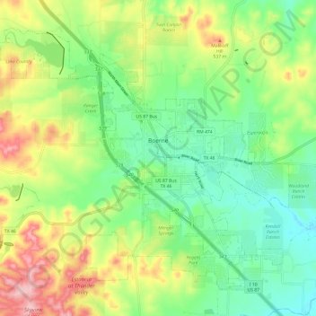
Name: Boerne topographic map, elevation, terrain.
Location: Boerne, Kendall County, Texas, United States (29.74552 -98.80201 29.83211 -98.68245)
Average elevation: 465 m
Minimum elevation: 398 m
Maximum elevation: 576 m
Other topographic maps
Click on a map to view its topography, its elevation and its terrain.
Bergheim
United States > Texas > Kendall County
Bergheim is an unincorporated community in eastern Kendall County, Texas, United States known for its German-Texan culture and heritage. It lies along State Highway 46 east of the city of Boerne, the county seat of Kendall County. Its elevation is 1,437 feet (438 m). Although Bergheim is unincorporated, it has…
Average elevation: 419 m