Geolocate

Mount Rigi topographic map

Click on the map to display elevation.

About this map

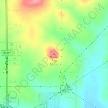
Name: Mount Rigi topographic map, elevation, terrain.

Location: Mount Rigi, Kendall County, Texas, 78013, United States (29.99378 -98.89036 29.99388 -98.89026)

Average elevation: 474 m

Minimum elevation: 435 m

Maximum elevation: 538 m

Other topographic maps

Click on a map to view its topography, its elevation and its terrain.

Boerne

United States > Texas > Kendall County

Average elevation: 465 m

Blackberry Creek

United States > Texas > Kendall County

Average elevation: 580 m

Boerne

United States > Texas > Kendall County

Average elevation: 465 m

Gear up for your next adventure:

🦶Hiking Shoe Insoles - Added support for high arches and long days on feet
🥾Mountain Trail Shoes - High-traction shoes for mountain trails
🥾Trail Running Shoes - Lightweight and durable shoes for trail running
🛏️Sleeping Bag - Warm and compact sleeping bags for outdoor camping
💧Reusable Water Bottle - Durable water bottles for hydration on trails

As an Amazon Associate, this site earns from qualifying purchases at no extra cost to you.